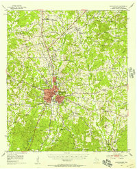
1952 Map of Nacogdoches
USGS Topo · Published 1958About this map
The deep red grid of Nacogdoches centers this East Texas landscape, showing the city's mid-century footprint anchored by Stephen F Austin College and the industrial hub at Hayward Junction. Significant historical routes define the area's movement, specifically the Old San Antonio Road cutting westward and the Southern Pacific line running north through Redfield Sta and Mahl. Outside the city, the map reveals a dense network of country schools and houses of worship, such as Old North Ch, Johnson Chapel, and Pine Flat Sch, which served the rural agricultural communities before consolidated modern growth.
Find a feature on this map
66 named features on this map. Tap any name to fly to it.
Don’t see what you’re looking for? This feature index may not catch every label — zoom into the map to look around manually.
Map Details
Editions of this 1952 Nacogdoches Map
3 editions found
Other maps of this area

1943 · Cushing
USGS Topo · 1:62,500

1945 · Cushing
USGS Topo · 1:62,500

1949 · Lufkin
USGS Topo · 1:62,500

1949 · Platt
USGS Topo · 1:24,000

1949 · Clawson
USGS Topo · 1:24,000

1950 · Platt
USGS Topo · 1:24,000

1950 · Clawson
USGS Topo · 1:24,000

1950 · Redland
USGS Topo · 1:24,000

1952 · Douglass
USGS Topo · 1:62,500

1952 · Nacogdoches
USGS Topo · 1:62,500