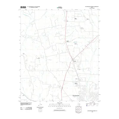
2010 Map of Nacogdoches North
USGS Topo · Published 2010About this map
Nacogdoches extends its northern footprint into this landscape defined by the convergence of the Bonita Creek and Bayou La Nana drainages. In the years following the millennium, the area shows a distinct pattern of rural communities and crossroads settlements such as Mahl, North Redland, and Central Heights connected by a network of local roads and highways. The terrain is notably etched by water, with the East Fork Bayou Loco and West Fork Bayou Loco winding through the western portion of the quadrangle. For those researching family history, the map provides precise locations for several local burial grounds, including the Old North Cemetery and Stone Cemetery. Water management is evident through features like the Robert W Murphey Dam and the Jerry W Allen Dam, which regulate the flow of the local bayous and create small reservoirs like Robert W Murphey Lake.
Find a feature on this map
28 named features on this map. Tap any name to fly to it.
Don’t see what you’re looking for? This feature index may not catch every label — zoom into the map to look around manually.
Map Details
Editions of this 2010 Nacogdoches North Map
This is the sole edition of this map. No revisions or reprints were ever made.
Other maps of this area

1943 · Cushing
USGS Topo · 1:62,500

1945 · Cushing
USGS Topo · 1:62,500

1952 · Douglass
USGS Topo · 1:62,500

1952 · Nacogdoches
USGS Topo · 1:62,500

1953 · Palestine
USGS Topo · 1:250,000

1957 · Palestine
USGS Topo · 1:250,000

1960 · Mount Enterprise
USGS Topo · 1:62,500

1973 · Cushing
USGS Topo · 1:24,000
1983 · Nacogdoches South
USGS Topo · 1:24,000
1983 · Lake Nacogdoches North
USGS Topo · 1:24,000