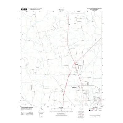
2013 Map of Nacogdoches North
USGS Topo · Published 2013About this map
Mahl and North Redland define the northern reaches of this East Texas landscape, where the terrain is carved by the Middle Fork Bayou Loco and E Fork Bayou Loco. The map reveals a transition from these rural settlements toward the northern edge of Nacogdoches, marked by the growth of Central Heights and the crossroads at Bonita Junction. Local history is anchored by several burial grounds, including the Hayter Cem in the west and the Johnson Cem near the eastern boundary. The presence of Robert W Murphey Lake and the Nacogdoches Springs highlights the importance of the region's hydrology, while the dendritic drainage patterns of Morral Bayou and Bayou La Nana underscore the creek-fed geography of the Pineywoods before it reaches the city proper.
Find a feature on this map
110 named features on this map. Tap any name to fly to it.
Don’t see what you’re looking for? This feature index may not catch every label — zoom into the map to look around manually.
Map Details
Editions of this 2013 Nacogdoches North Map
This is the sole edition of this map. No revisions or reprints were ever made.
Other maps of this area

1943 · Cushing
USGS Topo · 1:62,500

1945 · Cushing
USGS Topo · 1:62,500

1952 · Douglass
USGS Topo · 1:62,500

1952 · Nacogdoches
USGS Topo · 1:62,500

1953 · Palestine
USGS Topo · 1:250,000

1957 · Palestine
USGS Topo · 1:250,000

1960 · Mount Enterprise
USGS Topo · 1:62,500

1973 · Cushing
USGS Topo · 1:24,000
1983 · Nacogdoches South
USGS Topo · 1:24,000
1983 · Lake Nacogdoches North
USGS Topo · 1:24,000