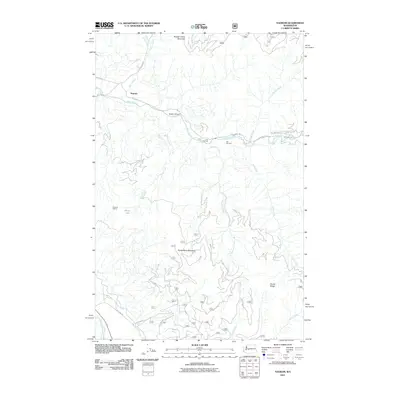
2011 Map of Nagrom
USGS Topo · Published 2011About this map
The Green River carves through the center of this King County landscape, passing through Green Canyon and past a site noted as Hot Springs. To the north, the settlement of Nagrom sits near the confluence of Smay Creek and its western fork, while high points like Rooster Comb Mountain and Huckleberry Mountain dominate the surrounding topography. This area is characterized by a dense network of Forest Service roads, including NFD 7000 RD and NFD 5480 RD, which provide access to the remote peaks and timberlands of the Cascades.
Find a feature on this map
31 named features on this map. Tap any name to fly to it.
Don’t see what you’re looking for? This feature index may not catch every label — zoom into the map to look around manually.
Map Details
Editions of this 2011 Nagrom Map
This is the sole edition of this map. No revisions or reprints were ever made.
Other maps of this area

1901 · Snoqualmie Pass
USGS Topo · 1:125,000

1903 · Snoqualmie
USGS Topo · 1:125,000

1913 · Cedar Lake
USGS Topo · 1:125,000

1956 · Greenwater
USGS Topo · 1:62,500

1957 · Wenatchee
USGS Topo · 1:250,000

1960 · Bandera
USGS Topo · 1:62,500

1961 · Snoqualmie Pass
USGS Topo · 1:62,500

1962 · Lester
USGS Topo · 1:62,500

1975 · Snoqualmie Pass
USGS Topo · 1:100,000
1986 · Nagrom
USGS Topo · 1:24,000