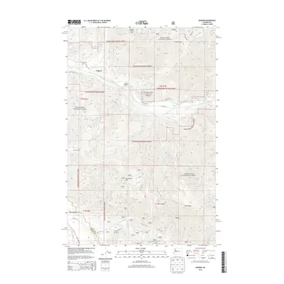
2014 Map of Nagrom
USGS Topo · Published 2014About this map
Snoqualmie National Forest dominates this mountain landscape, which is defined by the high elevations of the Cascade Range and the deep drainage basins of the Green River and White River. The settlement of Nagrom is situated along the northern banks of the Green River, a location once tied to timber and rail operations. To the south, the community of Greenwater marks the edge of the wilderness at the junction of the White River and the border between King and Pierce counties.
Find a feature on this map
38 named features on this map. Tap any name to fly to it.
Don’t see what you’re looking for? This feature index may not catch every label — zoom into the map to look around manually.
Map Details
Editions of this 2014 Nagrom Map
This is the sole edition of this map. No revisions or reprints were ever made.
Other maps of this area

1901 · Snoqualmie Pass
USGS Topo · 1:125,000

1903 · Snoqualmie
USGS Topo · 1:125,000

1913 · Cedar Lake
USGS Topo · 1:125,000

1956 · Greenwater
USGS Topo · 1:62,500

1957 · Wenatchee
USGS Topo · 1:250,000

1960 · Bandera
USGS Topo · 1:62,500

1961 · Snoqualmie Pass
USGS Topo · 1:62,500

1962 · Lester
USGS Topo · 1:62,500

1975 · Snoqualmie Pass
USGS Topo · 1:100,000
1986 · Nagrom
USGS Topo · 1:24,000