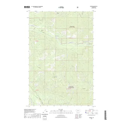
2020 Map of Nagrom
USGS Topo · Published 2020About this map
Nagrom sits along the Green River within the heart of the Snoqualmie National Forest, marking a landscape defined by the convergence of the Cascades' high ridges and deep river canyons. This area, spanning the King and Pierce County line, is characterized by a dense network of forest development roads and primitive paths like the Divide Trail. The map details the rugged drainage patterns of McCain Creek and Champion Creek, which feed into major waterways including the Greenwater River and White River.
Find a feature on this map
39 named features on this map. Tap any name to fly to it.
Don’t see what you’re looking for? This feature index may not catch every label — zoom into the map to look around manually.
Map Details
Editions of this 2020 Nagrom Map
This is the sole edition of this map. No revisions or reprints were ever made.
Other maps of this area

1901 · Snoqualmie Pass
USGS Topo · 1:125,000

1903 · Snoqualmie
USGS Topo · 1:125,000

1913 · Cedar Lake
USGS Topo · 1:125,000

1956 · Greenwater
USGS Topo · 1:62,500

1957 · Wenatchee
USGS Topo · 1:250,000

1960 · Bandera
USGS Topo · 1:62,500

1961 · Snoqualmie Pass
USGS Topo · 1:62,500

1962 · Lester
USGS Topo · 1:62,500

1975 · Snoqualmie Pass
USGS Topo · 1:100,000
1986 · Nagrom
USGS Topo · 1:24,000