
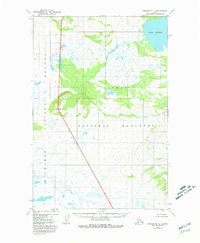
1951 Map of Naknek B-1
USGS Topo · Published 1956About this map
Lake Brooks sits in the northeast corner of this mid-century survey, a primary water feature in a landscape defined by complex hydrology and glacial relief. The area is characterized by an extensive network of small lakes and ponds, many of which are unnamed, suggesting a saturated and relatively undisturbed subarctic environment. The topography rises significantly at the landmark known as Granite, where elevation contours tighten to indicate a prominent peak or ridgeline.
Find a feature on this map
4 named features on this map. Tap any name to fly to it.
Don’t see what you’re looking for? This feature index may not catch every label — zoom into the map to look around manually.
Map Details
Editions of this 1951 Naknek B-1 Map
2 editions found
Other maps of this area

1948 · Mt Katmai
USGS Topo · 1:250,000

1951 · Mt Katmai
USGS Topo · 1:250,000

1951 · Mount Katmai A-6
USGS Topo · 1:63,360

1951 · Mount Katmai C-6
USGS Topo · 1:63,360

1951 · Mount Katmai B-6
USGS Topo · 1:63,360

1951 · Naknek C-1
USGS Topo · 1:63,360

1951 · Naknek A-2
USGS Topo · 1:63,360

1951 · Naknek A-1
USGS Topo · 1:63,360

1952 · Naknek
USGS Topo · 1:250,000

1952 · Naknek B-2
USGS Topo · 1:63,360