1952 Map of Naknek B-2
USGS Topo · Published 1958About this map
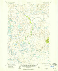
King Salmon River meanders across the southern portion of this mid-century survey, defining the primary drainage for an area characterized by an intricate network of small lakes and ponds. Based on 1951 aerial photography, the map documents a landscape before the introduction of roads or permanent structures, emphasizing the natural hydraulic patterns of the Alaskan interior. The King Salmon River itself is shown with numerous oxbows and small tributaries, indicating a low-gradient, high-sediment environment. This topography, while sparse in human development, offers a precise look at the land's original contours and water distribution as they existed prior to modern change in the region.
Find a feature on this map
1 named feature on this map. Tap any name to fly to it.
Don’t see what you’re looking for? This feature index may not catch every label — zoom into the map to look around manually.
Map Details
Editions of this 1952 Naknek B-2 Map
2 editions found
Historical Maps of Lake and Peninsula Through Time
732 maps found

1946 Lake Clark
Lake and Peninsula Borough, AK

1948 Mt Katmai
Lake and Peninsula Borough, AK

1951 Bristol Bay
Lake and Peninsula Borough, AK

1951 Dillingham A-1
Lake and Peninsula Borough, AK

1951 Iliamna A-6
Lake and Peninsula Borough, AK

1951 Iliamna A-7
Lake and Peninsula Borough, AK

1951 Iliamna A-8
Lake and Peninsula Borough, AK

1951 Iliamna B-5
Lake and Peninsula Borough, AK

1951 Iliamna B-6
Lake and Peninsula Borough, AK

1951 Iliamna B-7
Lake and Peninsula Borough, AK

1951 Karluk D-5
Lake and Peninsula Borough, AK

1951 Karluk D-6
Lake and Peninsula Borough, AK

1951 Lake Clark
Lake and Peninsula Borough, AK

1951 Mount Katmai A-6
Lake and Peninsula Borough, AK

1951 Mount Katmai B-3
Lake and Peninsula Borough, AK

1951 Mount Katmai B-5
Lake and Peninsula Borough, AK

1951 Mount Katmai B-6
Lake and Peninsula Borough, AK

1951 Mount Katmai C-2
Lake and Peninsula Borough, AK

1951 Mount Katmai C-3
Lake and Peninsula Borough, AK

1951 Mount Katmai C-4
Lake and Peninsula Borough, AK

1951 Mount Katmai C-5
Lake and Peninsula Borough, AK

1951 Mount Katmai C-6
Lake and Peninsula Borough, AK

1951 Mount Katmai D-3
Lake and Peninsula Borough, AK

1951 Mount Katmai D-4
Lake and Peninsula Borough, AK

1951 Mount Katmai D-6
Lake and Peninsula Borough, AK

1951 Mt. Katmai A-5
Lake and Peninsula Borough, AK

1951 Mt. Katmai B-4
Lake and Peninsula Borough, AK

1951 Mt. Katmai B-5
Lake and Peninsula Borough, AK

1951 Mt Katmai
Lake and Peninsula Borough, AK

1951 Naknek A-1
Lake and Peninsula Borough, AK

1951 Naknek A-2
Lake and Peninsula Borough, AK

1951 Naknek A-3
Lake and Peninsula Borough, AK

1951 Naknek A-4
Lake and Peninsula Borough, AK

1951 Naknek A-5
Lake and Peninsula Borough, AK

1951 Naknek B-1
Lake and Peninsula Borough, AK

1951 Naknek C-1
Lake and Peninsula Borough, AK

1951 Naknek D-1
Lake and Peninsula Borough, AK

1951 Stepovak Bay
Lake and Peninsula Borough, AK

1951 Sutwik Island
Lake and Peninsula Borough, AK

1951 Ugashik A-2
Lake and Peninsula Borough, AK

1951 Ugashik B-3
Lake and Peninsula Borough, AK

1951 Ugashik C-1
Lake and Peninsula Borough, AK

1951 Ugashik C-2
Lake and Peninsula Borough, AK

1951 Ugashik C-3
Lake and Peninsula Borough, AK

1951 Ugashik C-4
Lake and Peninsula Borough, AK

1951 Ugashik C-5
Lake and Peninsula Borough, AK

1951 Ugashik C-6
Lake and Peninsula Borough, AK

1951 Ugashik D-1
Lake and Peninsula Borough, AK

1951 Ugashik D-2
Lake and Peninsula Borough, AK

1951 Ugashik D-3
Lake and Peninsula Borough, AK

1951 Ugashik D-4
Lake and Peninsula Borough, AK

1951 Ugashik D-5 and D-6
Lake and Peninsula Borough, AK

1952 Dillingham A-2
Lake and Peninsula Borough, AK

1952 Dillingham A-3
Lake and Peninsula Borough, AK

1952 Iliamna A-8
Lake and Peninsula Borough, AK

1952 Naknek B-2
Lake and Peninsula Borough, AK

1952 Naknek B-3
Lake and Peninsula Borough, AK

1952 Naknek B-4
Lake and Peninsula Borough, AK

1952 Naknek B-5
Lake and Peninsula Borough, AK

1952 Naknek C-6
Lake and Peninsula Borough, AK

1953 Mount Katmai B-5
Lake and Peninsula Borough, AK

1953 Mount Katmai C-2
Lake and Peninsula Borough, AK

1953 Mount Katmai C-5
Lake and Peninsula Borough, AK

1953 Mt. Katmai B-6
Lake and Peninsula Borough, AK

1954 Dillingham B-1
Lake and Peninsula Borough, AK

1954 Dillingham B-2
Lake and Peninsula Borough, AK

1954 Iliamna B-5
Lake and Peninsula Borough, AK

1954 Iliamna B-6
Lake and Peninsula Borough, AK

1954 Iliamna B-8
Lake and Peninsula Borough, AK

1954 Iliamna C-3
Lake and Peninsula Borough, AK

1954 Iliamna C-4
Lake and Peninsula Borough, AK

1954 Iliamna C-5
Lake and Peninsula Borough, AK

1954 Iliamna C-6
Lake and Peninsula Borough, AK

1954 Iliamna C-7
Lake and Peninsula Borough, AK

1954 Iliamna C-8
Lake and Peninsula Borough, AK

1954 Iliamna D-3
Lake and Peninsula Borough, AK

1954 Iliamna D-4
Lake and Peninsula Borough, AK

1954 Iliamna D-5
Lake and Peninsula Borough, AK

1954 Iliamna D-6
Lake and Peninsula Borough, AK

1954 Iliamna D-7
Lake and Peninsula Borough, AK

1954 Iliamna D-8
Lake and Peninsula Borough, AK

1954 Lake Clark A-3
Lake and Peninsula Borough, AK

1954 Lake Clark A-4
Lake and Peninsula Borough, AK

1954 Lake Clark A-5
Lake and Peninsula Borough, AK

1954 Lake Clark A-6
Lake and Peninsula Borough, AK

1954 Lake Clark A-7
Lake and Peninsula Borough, AK

1954 Lake Clark A-8
Lake and Peninsula Borough, AK

1954 Lake Clark B-3
Lake and Peninsula Borough, AK

1954 Lake Clark B-4
Lake and Peninsula Borough, AK

1954 Lake Clark B-5
Lake and Peninsula Borough, AK

1954 Lake Clark B-6
Lake and Peninsula Borough, AK

1954 Lake Clark B-7
Lake and Peninsula Borough, AK

1954 Lake Clark B-8
Lake and Peninsula Borough, AK

1954 Lake Clark C-3
Lake and Peninsula Borough, AK

1954 Lake Clark C-4
Lake and Peninsula Borough, AK

1954 Lake Clark C-5
Lake and Peninsula Borough, AK

1954 Lake Clark C-6
Lake and Peninsula Borough, AK

1954 Lake Clark C-7
Lake and Peninsula Borough, AK

1954 Lake Clark C-8
Lake and Peninsula Borough, AK

1954 Lake Clark D-3
Lake and Peninsula Borough, AK

1954 Lake Clark D-4
Lake and Peninsula Borough, AK

1954 Lake Clark D-5
Lake and Peninsula Borough, AK

1954 Lake Clark D-6
Lake and Peninsula Borough, AK

1954 Lake Clark D-7
Lake and Peninsula Borough, AK

1954 Lake Clark D-8
Lake and Peninsula Borough, AK

1954 Sutwik Island D-3
Lake and Peninsula Borough, AK

1954 Ugashik A-3
Lake and Peninsula Borough, AK

1954 Ugashik B-4
Lake and Peninsula Borough, AK

1954 Ugashik B-5
Lake and Peninsula Borough, AK

1958 Lake Clark B-2
Lake and Peninsula Borough, AK

1958 Lake Clark C-2
Lake and Peninsula Borough, AK

1958 Lake Clark D-2
Lake and Peninsula Borough, AK

1958 Lake Clark
Lake and Peninsula Borough, AK

1963 Bristol Bay A-1
Lake and Peninsula Borough, AK

1963 Bristol Bay A-2
Lake and Peninsula Borough, AK

1963 Bristol Bay B-1
Lake and Peninsula Borough, AK

1963 Bristol Bay
Lake and Peninsula Borough, AK

1963 Chignik A-1
Lake and Peninsula Borough, AK

1963 Chignik A-2
Lake and Peninsula Borough, AK

1963 Chignik A-3
Lake and Peninsula Borough, AK

1963 Chignik A-4
Lake and Peninsula Borough, AK

1963 Chignik A-5
Lake and Peninsula Borough, AK

1963 Chignik B-1
Lake and Peninsula Borough, AK

1963 Chignik B-2
Lake and Peninsula Borough, AK

1963 Chignik B-3
Lake and Peninsula Borough, AK

1963 Chignik B-4
Lake and Peninsula Borough, AK

1963 Chignik B-5
Lake and Peninsula Borough, AK

1963 Chignik B-6
Lake and Peninsula Borough, AK

1963 Chignik C-1
Lake and Peninsula Borough, AK

1963 Chignik C-2
Lake and Peninsula Borough, AK

1963 Chignik C-3
Lake and Peninsula Borough, AK

1963 Chignik C-4
Lake and Peninsula Borough, AK

1963 Chignik D-1
Lake and Peninsula Borough, AK

1963 Chignik D-2
Lake and Peninsula Borough, AK

1963 Chignik D-3
Lake and Peninsula Borough, AK

1963 Stepovak Bay D-2
Lake and Peninsula Borough, AK

1963 Stepovak Bay D-3
Lake and Peninsula Borough, AK

1963 Stepovak Bay D-4
Lake and Peninsula Borough, AK

1963 Stepovak Bay D-5
Lake and Peninsula Borough, AK

1963 Stepovak Bay
Lake and Peninsula Borough, AK

1963 Sutwik Island B-6
Lake and Peninsula Borough, AK

1963 Sutwik Island C-4
Lake and Peninsula Borough, AK

1963 Sutwik Island C-5
Lake and Peninsula Borough, AK

1963 Sutwik Island C-6
Lake and Peninsula Borough, AK

1963 Sutwik Island D-4
Lake and Peninsula Borough, AK

1963 Sutwik Island D-5
Lake and Peninsula Borough, AK

1963 Sutwik Island D-6
Lake and Peninsula Borough, AK

1963 Sutwik Island
Lake and Peninsula Borough, AK

1963 Ugashik A-4
Lake and Peninsula Borough, AK

1963 Ugashik A-5
Lake and Peninsula Borough, AK

1963 Ugashik A-6
Lake and Peninsula Borough, AK

1963 Ugashik B-6
Lake and Peninsula Borough, AK

1964 Mt. Katmai
Lake and Peninsula Borough, AK

1967 Bristol Bay
Lake and Peninsula Borough, AK

1969 Stepovak Bay
Lake and Peninsula Borough, AK

1989 Sutwik Island D-2
Lake and Peninsula Borough, AK

2018 Iliamna A-5 NW
Lake and Peninsula Borough, AK

2018 Iliamna A-5 SW
Lake and Peninsula Borough, AK

2018 Iliamna B-4 NE
Lake and Peninsula Borough, AK

2018 Iliamna B-4 NW
Lake and Peninsula Borough, AK

2018 Iliamna B-5 NE
Lake and Peninsula Borough, AK

2018 Iliamna B-5 NW
Lake and Peninsula Borough, AK

2018 Iliamna B-5 SE
Lake and Peninsula Borough, AK

2018 Iliamna B-5 SW
Lake and Peninsula Borough, AK

2018 Iliamna C-3 NW
Lake and Peninsula Borough, AK

2018 Iliamna C-4 NE
Lake and Peninsula Borough, AK

2018 Iliamna C-4 NW
Lake and Peninsula Borough, AK

2018 Iliamna C-4 SE
Lake and Peninsula Borough, AK

2018 Iliamna C-4 SW
Lake and Peninsula Borough, AK

2018 Iliamna C-5 NE
Lake and Peninsula Borough, AK

2018 Iliamna C-5 NW
Lake and Peninsula Borough, AK

2018 Iliamna C-5 SE
Lake and Peninsula Borough, AK

2018 Iliamna C-5 SW
Lake and Peninsula Borough, AK

2018 Iliamna D-3 NE
Lake and Peninsula Borough, AK

2018 Iliamna D-3 SE
Lake and Peninsula Borough, AK

2018 Iliamna D-3 SW
Lake and Peninsula Borough, AK

2018 Iliamna D-4 NE
Lake and Peninsula Borough, AK

2018 Iliamna D-4 NW
Lake and Peninsula Borough, AK

2018 Iliamna D-4 SE
Lake and Peninsula Borough, AK

2018 Iliamna D-4 SW
Lake and Peninsula Borough, AK

2018 Iliamna D-5 NE
Lake and Peninsula Borough, AK

2018 Iliamna D-5 NW
Lake and Peninsula Borough, AK

2018 Iliamna D-5 SE
Lake and Peninsula Borough, AK

2018 Iliamna D-5 SW
Lake and Peninsula Borough, AK

2018 Lake Clark A-2 NW
Lake and Peninsula Borough, AK

2018 Lake Clark A-2 SW
Lake and Peninsula Borough, AK

2018 Lake Clark A-3 NE
Lake and Peninsula Borough, AK

2018 Lake Clark A-3 SE
Lake and Peninsula Borough, AK

2018 Lake Clark A-4 NE
Lake and Peninsula Borough, AK

2018 Lake Clark A-4 NW
Lake and Peninsula Borough, AK

2018 Lake Clark A-4 SE
Lake and Peninsula Borough, AK

2018 Lake Clark A-4 SW
Lake and Peninsula Borough, AK

2018 Lake Clark A-5 NE
Lake and Peninsula Borough, AK

2018 Lake Clark A-5 NW
Lake and Peninsula Borough, AK

2018 Lake Clark A-5 SE
Lake and Peninsula Borough, AK

2018 Lake Clark A-5 SW
Lake and Peninsula Borough, AK

2018 Lake Clark B-2 NW
Lake and Peninsula Borough, AK

2018 Lake Clark B-2 SW
Lake and Peninsula Borough, AK

2018 Lake Clark B-3 NE
Lake and Peninsula Borough, AK

2018 Lake Clark B-3 SE
Lake and Peninsula Borough, AK

2018 Lake Clark B-4 NE
Lake and Peninsula Borough, AK

2018 Lake Clark B-4 NW
Lake and Peninsula Borough, AK

2018 Lake Clark B-4 SE
Lake and Peninsula Borough, AK

2018 Lake Clark B-4 SW
Lake and Peninsula Borough, AK

2018 Lake Clark B-5 NE
Lake and Peninsula Borough, AK

2018 Lake Clark B-5 NW
Lake and Peninsula Borough, AK

2018 Lake Clark B-5 SE
Lake and Peninsula Borough, AK

2018 Lake Clark B-5 SW
Lake and Peninsula Borough, AK

2018 Lake Clark C-2 NE
Lake and Peninsula Borough, AK

2018 Lake Clark C-2 NW
Lake and Peninsula Borough, AK

2018 Lake Clark C-2 SE
Lake and Peninsula Borough, AK

2018 Lake Clark C-2 SW
Lake and Peninsula Borough, AK

2018 Lake Clark C-3 NE
Lake and Peninsula Borough, AK

2018 Lake Clark C-3 SE
Lake and Peninsula Borough, AK

2018 Lake Clark C-4 NE
Lake and Peninsula Borough, AK

2018 Lake Clark C-4 NW
Lake and Peninsula Borough, AK

2018 Lake Clark C-4 SE
Lake and Peninsula Borough, AK

2018 Lake Clark C-4 SW
Lake and Peninsula Borough, AK

2018 Lake Clark C-5 NE
Lake and Peninsula Borough, AK

2018 Lake Clark C-5 NW
Lake and Peninsula Borough, AK

2018 Lake Clark C-5 SE
Lake and Peninsula Borough, AK

2018 Lake Clark C-5 SW
Lake and Peninsula Borough, AK

2018 Lake Clark D-2 SE
Lake and Peninsula Borough, AK

2018 Lake Clark D-2 SW
Lake and Peninsula Borough, AK

2018 Lake Clark D-3 SE
Lake and Peninsula Borough, AK

2018 Lake Clark D-4 SE
Lake and Peninsula Borough, AK

2018 Lake Clark D-4 SW
Lake and Peninsula Borough, AK

2018 Lake Clark D-5 SE
Lake and Peninsula Borough, AK

2018 Lake Clark D-5 SW
Lake and Peninsula Borough, AK

2019 Bristol Bay A-1 NE
Lake and Peninsula Borough, AK

2019 Bristol Bay A-1 NW
Lake and Peninsula Borough, AK

2019 Bristol Bay A-1 SE
Lake and Peninsula Borough, AK

2019 Bristol Bay A-1 SW
Lake and Peninsula Borough, AK

2019 Bristol Bay A-2 NE
Lake and Peninsula Borough, AK

2019 Bristol Bay A-2 NW
Lake and Peninsula Borough, AK

2019 Bristol Bay A-2 OE W SE
Lake and Peninsula Borough, AK

2019 Bristol Bay A-2 SE
Lake and Peninsula Borough, AK

2019 Bristol Bay A-2 SW
Lake and Peninsula Borough, AK

2019 Bristol Bay B-1 NE
Lake and Peninsula Borough, AK

2019 Bristol Bay B-1 NW
Lake and Peninsula Borough, AK

2019 Bristol Bay B-1 OE W SE
Lake and Peninsula Borough, AK

2019 Bristol Bay B-1 SE
Lake and Peninsula Borough, AK

2019 Bristol Bay B-1 SW
Lake and Peninsula Borough, AK

2019 Dillingham A-1 NE
Lake and Peninsula Borough, AK

2019 Dillingham A-1 NW
Lake and Peninsula Borough, AK

2019 Dillingham A-1 SE
Lake and Peninsula Borough, AK

2019 Dillingham A-1 SW
Lake and Peninsula Borough, AK

2019 Dillingham A-2 NE
Lake and Peninsula Borough, AK

2019 Dillingham A-2 NW
Lake and Peninsula Borough, AK

2019 Dillingham A-2 SE
Lake and Peninsula Borough, AK

2019 Dillingham A-2 SW
Lake and Peninsula Borough, AK

2019 Dillingham A-3 NE
Lake and Peninsula Borough, AK

2019 Dillingham A-3 NW
Lake and Peninsula Borough, AK

2019 Dillingham A-3 SE
Lake and Peninsula Borough, AK

2019 Dillingham A-3 SW
Lake and Peninsula Borough, AK

2019 Dillingham A-4 NE
Lake and Peninsula Borough, AK

2019 Dillingham B-1 NE
Lake and Peninsula Borough, AK

2019 Dillingham B-1 NW
Lake and Peninsula Borough, AK

2019 Dillingham B-1 SE
Lake and Peninsula Borough, AK

2019 Dillingham B-1 SW
Lake and Peninsula Borough, AK

2019 Dillingham B-2 NE
Lake and Peninsula Borough, AK

2019 Dillingham B-2 NW
Lake and Peninsula Borough, AK

2019 Dillingham B-2 SE
Lake and Peninsula Borough, AK

2019 Dillingham B-2 SW
Lake and Peninsula Borough, AK

2019 Dillingham B-3 SE
Lake and Peninsula Borough, AK

2019 Dillingham C-1 SE
Lake and Peninsula Borough, AK

2019 Dillingham C-1 SW
Lake and Peninsula Borough, AK

2019 Iliamna A-6 NE
Lake and Peninsula Borough, AK

2019 Iliamna A-6 NW
Lake and Peninsula Borough, AK

2019 Iliamna A-6 SE
Lake and Peninsula Borough, AK

2019 Iliamna A-6 SW
Lake and Peninsula Borough, AK

2019 Iliamna A-7 NE
Lake and Peninsula Borough, AK

2019 Iliamna A-7 NW
Lake and Peninsula Borough, AK

2019 Iliamna A-7 SE
Lake and Peninsula Borough, AK

2019 Iliamna A-7 SW
Lake and Peninsula Borough, AK

2019 Iliamna A-8 NE
Lake and Peninsula Borough, AK

2019 Iliamna A-8 NW
Lake and Peninsula Borough, AK

2019 Iliamna A-8 SE
Lake and Peninsula Borough, AK

2019 Iliamna A-8 SW
Lake and Peninsula Borough, AK

2019 Iliamna B-6 NE
Lake and Peninsula Borough, AK

2019 Iliamna B-6 NW
Lake and Peninsula Borough, AK

2019 Iliamna B-6 SE
Lake and Peninsula Borough, AK

2019 Iliamna B-6 SW
Lake and Peninsula Borough, AK

2019 Iliamna B-7 NE
Lake and Peninsula Borough, AK

2019 Iliamna B-7 SE
Lake and Peninsula Borough, AK

2019 Iliamna B-7 SW
Lake and Peninsula Borough, AK

2019 Iliamna B-8 NW
Lake and Peninsula Borough, AK

2019 Iliamna B-8 SE
Lake and Peninsula Borough, AK

2019 Iliamna B-8 SW
Lake and Peninsula Borough, AK

2019 Iliamna C-6 NE
Lake and Peninsula Borough, AK

2019 Iliamna C-6 NW
Lake and Peninsula Borough, AK

2019 Iliamna C-6 SE
Lake and Peninsula Borough, AK

2019 Iliamna C-7 NE
Lake and Peninsula Borough, AK

2019 Iliamna C-7 NW
Lake and Peninsula Borough, AK

2019 Iliamna C-7 SE
Lake and Peninsula Borough, AK

2019 Iliamna C-7 SW
Lake and Peninsula Borough, AK

2019 Iliamna C-8 NE
Lake and Peninsula Borough, AK

2019 Iliamna C-8 NW
Lake and Peninsula Borough, AK

2019 Iliamna C-8 SE
Lake and Peninsula Borough, AK

2019 Iliamna C-8 SW
Lake and Peninsula Borough, AK

2019 Iliamna D-6 NE
Lake and Peninsula Borough, AK

2019 Iliamna D-6 NW
Lake and Peninsula Borough, AK

2019 Iliamna D-6 SE
Lake and Peninsula Borough, AK

2019 Iliamna D-6 SW
Lake and Peninsula Borough, AK

2019 Iliamna D-7 NE
Lake and Peninsula Borough, AK

2019 Iliamna D-7 NW
Lake and Peninsula Borough, AK

2019 Iliamna D-7 SE
Lake and Peninsula Borough, AK

2019 Iliamna D-7 SW
Lake and Peninsula Borough, AK

2019 Iliamna D-8 NE
Lake and Peninsula Borough, AK

2019 Iliamna D-8 NW
Lake and Peninsula Borough, AK

2019 Iliamna D-8 SE
Lake and Peninsula Borough, AK

2019 Iliamna D-8 SW
Lake and Peninsula Borough, AK

2019 Karluk C-6 NW
Lake and Peninsula Borough, AK

2019 Karluk D-5 NE
Lake and Peninsula Borough, AK

2019 Karluk D-5 NW
Lake and Peninsula Borough, AK

2019 Karluk D-5 SW
Lake and Peninsula Borough, AK

2019 Karluk D-6 NE
Lake and Peninsula Borough, AK

2019 Karluk D-6 NW
Lake and Peninsula Borough, AK

2019 Karluk D-6 SE
Lake and Peninsula Borough, AK

2019 Karluk D-6 SW
Lake and Peninsula Borough, AK

2019 Lake Clark A-6 NE
Lake and Peninsula Borough, AK

2019 Lake Clark A-6 NW
Lake and Peninsula Borough, AK

2019 Lake Clark A-6 SE
Lake and Peninsula Borough, AK

2019 Lake Clark A-6 SW
Lake and Peninsula Borough, AK

2019 Lake Clark A-7 NE
Lake and Peninsula Borough, AK

2019 Lake Clark A-7 NW
Lake and Peninsula Borough, AK

2019 Lake Clark A-7 SE
Lake and Peninsula Borough, AK

2019 Lake Clark A-7 SW
Lake and Peninsula Borough, AK

2019 Lake Clark A-8 NE
Lake and Peninsula Borough, AK

2019 Lake Clark A-8 NW
Lake and Peninsula Borough, AK

2019 Lake Clark A-8 SE
Lake and Peninsula Borough, AK

2019 Lake Clark A-8 SW
Lake and Peninsula Borough, AK

2019 Lake Clark B-6 NE
Lake and Peninsula Borough, AK

2019 Lake Clark B-6 NW
Lake and Peninsula Borough, AK

2019 Lake Clark B-6 SE
Lake and Peninsula Borough, AK

2019 Lake Clark B-6 SW
Lake and Peninsula Borough, AK

2019 Lake Clark B-7 NE
Lake and Peninsula Borough, AK

2019 Lake Clark B-7 NW
Lake and Peninsula Borough, AK

2019 Lake Clark B-7 SE
Lake and Peninsula Borough, AK

2019 Lake Clark B-7 SW
Lake and Peninsula Borough, AK

2019 Lake Clark B-8 NE
Lake and Peninsula Borough, AK

2019 Lake Clark B-8 NW
Lake and Peninsula Borough, AK

2019 Lake Clark B-8 SE
Lake and Peninsula Borough, AK

2019 Lake Clark B-8 SW
Lake and Peninsula Borough, AK

2019 Lake Clark C-6 NE
Lake and Peninsula Borough, AK

2019 Lake Clark C-6 NW
Lake and Peninsula Borough, AK

2019 Lake Clark C-6 SE
Lake and Peninsula Borough, AK

2019 Lake Clark C-6 SW
Lake and Peninsula Borough, AK

2019 Lake Clark C-7 NE
Lake and Peninsula Borough, AK

2019 Lake Clark C-7 NW
Lake and Peninsula Borough, AK

2019 Lake Clark C-7 SE
Lake and Peninsula Borough, AK

2019 Lake Clark C-7 SW
Lake and Peninsula Borough, AK

2019 Lake Clark C-8 NE
Lake and Peninsula Borough, AK

2019 Lake Clark C-8 NW
Lake and Peninsula Borough, AK

2019 Lake Clark C-8 SE
Lake and Peninsula Borough, AK

2019 Lake Clark C-8 SW
Lake and Peninsula Borough, AK

2019 Lake Clark D-6 SE
Lake and Peninsula Borough, AK

2019 Lake Clark D-6 SW
Lake and Peninsula Borough, AK

2019 Lake Clark D-7 SE
Lake and Peninsula Borough, AK

2019 Lake Clark D-7 SW
Lake and Peninsula Borough, AK

2019 Lake Clark D-8 SE
Lake and Peninsula Borough, AK

2019 Lake Clark D-8 SW
Lake and Peninsula Borough, AK

2019 Mount Katmai A-1 NE
Lake and Peninsula Borough, AK

2019 Mount Katmai A-1 NW
Lake and Peninsula Borough, AK

2019 Mount Katmai A-1 SW
Lake and Peninsula Borough, AK

2019 Mount Katmai A-2 NE
Lake and Peninsula Borough, AK

2019 Mount Katmai A-2 NW
Lake and Peninsula Borough, AK

2019 Mount Katmai A-2 SE
Lake and Peninsula Borough, AK

2019 Mount Katmai A-2 SW
Lake and Peninsula Borough, AK

2019 Mount Katmai A-3 NE
Lake and Peninsula Borough, AK

2019 Mount Katmai A-3 NW
Lake and Peninsula Borough, AK

2019 Mount Katmai A-3 SE
Lake and Peninsula Borough, AK

2019 Mount Katmai A-3 SW
Lake and Peninsula Borough, AK

2019 Mount Katmai A-4 NE
Lake and Peninsula Borough, AK

2019 Mount Katmai A-4 NW
Lake and Peninsula Borough, AK

2019 Mount Katmai A-4 SE
Lake and Peninsula Borough, AK

2019 Mount Katmai A-4 SW
Lake and Peninsula Borough, AK

2019 Mount Katmai A-5 NE
Lake and Peninsula Borough, AK

2019 Mount Katmai A-5 NW
Lake and Peninsula Borough, AK

2019 Mount Katmai A-5 SE
Lake and Peninsula Borough, AK

2019 Mount Katmai A-5 SW
Lake and Peninsula Borough, AK

2019 Mount Katmai A-6 NE
Lake and Peninsula Borough, AK

2019 Mount Katmai A-6 NW
Lake and Peninsula Borough, AK

2019 Mount Katmai A-6 SE
Lake and Peninsula Borough, AK

2019 Mount Katmai A-6 SW
Lake and Peninsula Borough, AK

2019 Mount Katmai B-1 NE
Lake and Peninsula Borough, AK

2019 Mount Katmai B-1 NW
Lake and Peninsula Borough, AK

2019 Mount Katmai B-1 OE E NW
Lake and Peninsula Borough, AK

2019 Mount Katmai B-1 OE E SW
Lake and Peninsula Borough, AK

2019 Mount Katmai B-1 SE
Lake and Peninsula Borough, AK

2019 Mount Katmai B-1 SW
Lake and Peninsula Borough, AK

2019 Mount Katmai B-2 NE
Lake and Peninsula Borough, AK

2019 Mount Katmai B-2 NW
Lake and Peninsula Borough, AK

2019 Mount Katmai B-2 SE
Lake and Peninsula Borough, AK

2019 Mount Katmai B-2 SW
Lake and Peninsula Borough, AK

2019 Mount Katmai B-3 NE
Lake and Peninsula Borough, AK

2019 Mount Katmai B-3 NW
Lake and Peninsula Borough, AK

2019 Mount Katmai B-3 SE
Lake and Peninsula Borough, AK

2019 Mount Katmai B-3 SW
Lake and Peninsula Borough, AK

2019 Mount Katmai B-4 NE
Lake and Peninsula Borough, AK

2019 Mount Katmai B-4 NW
Lake and Peninsula Borough, AK

2019 Mount Katmai B-4 SE
Lake and Peninsula Borough, AK

2019 Mount Katmai B-4 SW
Lake and Peninsula Borough, AK

2019 Mount Katmai B-5 NE
Lake and Peninsula Borough, AK

2019 Mount Katmai B-5 NW
Lake and Peninsula Borough, AK

2019 Mount Katmai B-5 SE
Lake and Peninsula Borough, AK

2019 Mount Katmai B-5 SW
Lake and Peninsula Borough, AK

2019 Mount Katmai B-6 NE
Lake and Peninsula Borough, AK

2019 Mount Katmai B-6 NW
Lake and Peninsula Borough, AK

2019 Mount Katmai B-6 SE
Lake and Peninsula Borough, AK

2019 Mount Katmai B-6 SW
Lake and Peninsula Borough, AK

2019 Mount Katmai C-1 SE
Lake and Peninsula Borough, AK

2019 Mount Katmai C-1 SW
Lake and Peninsula Borough, AK

2019 Mount Katmai C-2 SE
Lake and Peninsula Borough, AK

2019 Mount Katmai C-2 SW
Lake and Peninsula Borough, AK

2019 Mount Katmai C-3 NE
Lake and Peninsula Borough, AK

2019 Mount Katmai C-3 NW
Lake and Peninsula Borough, AK

2019 Mount Katmai C-3 SE
Lake and Peninsula Borough, AK

2019 Mount Katmai C-3 SW
Lake and Peninsula Borough, AK

2019 Mount Katmai C-4 NE
Lake and Peninsula Borough, AK

2019 Mount Katmai C-4 NW
Lake and Peninsula Borough, AK

2019 Mount Katmai C-4 SE
Lake and Peninsula Borough, AK

2019 Mount Katmai C-4 SW
Lake and Peninsula Borough, AK

2019 Mount Katmai C-5 NE
Lake and Peninsula Borough, AK

2019 Mount Katmai C-5 NW
Lake and Peninsula Borough, AK

2019 Mount Katmai C-5 SE
Lake and Peninsula Borough, AK

2019 Mount Katmai C-5 SW
Lake and Peninsula Borough, AK

2019 Mount Katmai C-6 NE
Lake and Peninsula Borough, AK

2019 Mount Katmai C-6 NW
Lake and Peninsula Borough, AK

2019 Mount Katmai C-6 SE
Lake and Peninsula Borough, AK

2019 Mount Katmai C-6 SW
Lake and Peninsula Borough, AK

2019 Mount Katmai D-3 NE
Lake and Peninsula Borough, AK

2019 Mount Katmai D-3 NW
Lake and Peninsula Borough, AK

2019 Mount Katmai D-3 SE
Lake and Peninsula Borough, AK

2019 Mount Katmai D-3 SW
Lake and Peninsula Borough, AK

2019 Mount Katmai D-4 NE
Lake and Peninsula Borough, AK

2019 Mount Katmai D-4 NW
Lake and Peninsula Borough, AK

2019 Mount Katmai D-4 SE
Lake and Peninsula Borough, AK

2019 Mount Katmai D-4 SW
Lake and Peninsula Borough, AK

2019 Mount Katmai D-5 NE
Lake and Peninsula Borough, AK

2019 Mount Katmai D-5 NW
Lake and Peninsula Borough, AK

2019 Mount Katmai D-5 SE
Lake and Peninsula Borough, AK

2019 Mount Katmai D-5 SW
Lake and Peninsula Borough, AK

2019 Mount Katmai D-6 NE
Lake and Peninsula Borough, AK

2019 Mount Katmai D-6 NW
Lake and Peninsula Borough, AK

2019 Mount Katmai D-6 SE
Lake and Peninsula Borough, AK

2019 Mount Katmai D-6 SW
Lake and Peninsula Borough, AK

2019 Naknek A-1 NE
Lake and Peninsula Borough, AK

2019 Naknek A-1 NW
Lake and Peninsula Borough, AK

2019 Naknek A-1 SE
Lake and Peninsula Borough, AK

2019 Naknek A-1 SW
Lake and Peninsula Borough, AK

2019 Naknek A-2 NE
Lake and Peninsula Borough, AK

2019 Naknek A-2 NW
Lake and Peninsula Borough, AK

2019 Naknek A-2 SE
Lake and Peninsula Borough, AK

2019 Naknek A-2 SW
Lake and Peninsula Borough, AK

2019 Naknek A-3 NE
Lake and Peninsula Borough, AK

2019 Naknek A-3 NW
Lake and Peninsula Borough, AK

2019 Naknek A-3 SE
Lake and Peninsula Borough, AK

2019 Naknek A-3 SW
Lake and Peninsula Borough, AK

2019 Naknek A-4 NE
Lake and Peninsula Borough, AK

2019 Naknek A-4 NW
Lake and Peninsula Borough, AK

2019 Naknek A-4 SE
Lake and Peninsula Borough, AK

2019 Naknek A-4 SW
Lake and Peninsula Borough, AK

2019 Naknek A-5 NE
Lake and Peninsula Borough, AK

2019 Naknek A-5 NW
Lake and Peninsula Borough, AK

2019 Naknek A-5 SE
Lake and Peninsula Borough, AK

2019 Naknek A-5 SW
Lake and Peninsula Borough, AK

2019 Naknek B-1 NE
Lake and Peninsula Borough, AK

2019 Naknek B-1 NW
Lake and Peninsula Borough, AK

2019 Naknek B-1 SE
Lake and Peninsula Borough, AK

2019 Naknek B-1 SW
Lake and Peninsula Borough, AK

2019 Naknek B-2 NE
Lake and Peninsula Borough, AK

2019 Naknek B-2 NW
Lake and Peninsula Borough, AK

2019 Naknek B-2 SE
Lake and Peninsula Borough, AK

2019 Naknek B-2 SW
Lake and Peninsula Borough, AK

2019 Naknek B-3 NE
Lake and Peninsula Borough, AK

2019 Naknek B-3 NW
Lake and Peninsula Borough, AK

2019 Naknek B-3 SE
Lake and Peninsula Borough, AK

2019 Naknek B-3 SW
Lake and Peninsula Borough, AK

2019 Naknek B-4 NE
Lake and Peninsula Borough, AK

2019 Naknek B-4 NW
Lake and Peninsula Borough, AK

2019 Naknek B-4 SE
Lake and Peninsula Borough, AK

2019 Naknek B-4 SW
Lake and Peninsula Borough, AK

2019 Naknek B-5 NE
Lake and Peninsula Borough, AK

2019 Naknek B-5 NW
Lake and Peninsula Borough, AK

2019 Naknek B-5 SE
Lake and Peninsula Borough, AK

2019 Naknek B-5 SW
Lake and Peninsula Borough, AK

2019 Naknek C-1 NE
Lake and Peninsula Borough, AK

2019 Naknek C-1 NW
Lake and Peninsula Borough, AK

2019 Naknek C-1 SE
Lake and Peninsula Borough, AK

2019 Naknek C-1 SW
Lake and Peninsula Borough, AK

2019 Naknek C-2 SE
Lake and Peninsula Borough, AK

2019 Naknek C-2 SW
Lake and Peninsula Borough, AK

2019 Naknek C-3 SE
Lake and Peninsula Borough, AK

2019 Naknek C-3 SW
Lake and Peninsula Borough, AK

2019 Naknek C-4 SE
Lake and Peninsula Borough, AK

2019 Naknek C-4 SW
Lake and Peninsula Borough, AK

2019 Naknek C-5 SE
Lake and Peninsula Borough, AK

2019 Naknek D-1 NE
Lake and Peninsula Borough, AK

2019 Naknek D-1 NW
Lake and Peninsula Borough, AK

2019 Naknek D-1 SE
Lake and Peninsula Borough, AK

2019 Naknek D-1 SW
Lake and Peninsula Borough, AK

2019 Naknek D-2 NE
Lake and Peninsula Borough, AK

2019 Naknek D-2 NW
Lake and Peninsula Borough, AK

2019 Naknek D-3 NE
Lake and Peninsula Borough, AK

2019 Naknek D-3 NW
Lake and Peninsula Borough, AK

2019 Naknek D-4 NE
Lake and Peninsula Borough, AK

2019 Naknek D-4 NW
Lake and Peninsula Borough, AK

2019 Sutwik Island A-3 NE
Lake and Peninsula Borough, AK

2019 Sutwik Island A-3 OE E SW
Lake and Peninsula Borough, AK

2019 Sutwik Island A-3 SE
Lake and Peninsula Borough, AK

2019 Sutwik Island B-6 NE
Lake and Peninsula Borough, AK

2019 Sutwik Island B-6 NW
Lake and Peninsula Borough, AK

2019 Sutwik Island B-6 SE
Lake and Peninsula Borough, AK

2019 Sutwik Island B-6 SW
Lake and Peninsula Borough, AK

2019 Sutwik Island C-4 NE
Lake and Peninsula Borough, AK

2019 Sutwik Island C-4 OE E SW
Lake and Peninsula Borough, AK

2019 Sutwik Island C-4 SE
Lake and Peninsula Borough, AK

2019 Sutwik Island C-4 SW
Lake and Peninsula Borough, AK

2019 Sutwik Island C-5 NE
Lake and Peninsula Borough, AK

2019 Sutwik Island C-5 NW
Lake and Peninsula Borough, AK

2019 Sutwik Island C-5 SE
Lake and Peninsula Borough, AK

2019 Sutwik Island C-5 SW
Lake and Peninsula Borough, AK

2019 Sutwik Island C-6 NE
Lake and Peninsula Borough, AK

2019 Sutwik Island C-6 NW
Lake and Peninsula Borough, AK

2019 Sutwik Island C-6 SE
Lake and Peninsula Borough, AK

2019 Sutwik Island C-6 SW
Lake and Peninsula Borough, AK

2019 Sutwik Island D-2 NE
Lake and Peninsula Borough, AK

2019 Sutwik Island D-2 NW
Lake and Peninsula Borough, AK

2019 Sutwik Island D-3 NE
Lake and Peninsula Borough, AK

2019 Sutwik Island D-3 NW
Lake and Peninsula Borough, AK

2019 Sutwik Island D-3 SE
Lake and Peninsula Borough, AK

2019 Sutwik Island D-3 SW
Lake and Peninsula Borough, AK

2019 Sutwik Island D-4 NE
Lake and Peninsula Borough, AK

2019 Sutwik Island D-4 NW
Lake and Peninsula Borough, AK

2019 Sutwik Island D-4 SE
Lake and Peninsula Borough, AK

2019 Sutwik Island D-4 SW
Lake and Peninsula Borough, AK

2019 Sutwik Island D-5 NE
Lake and Peninsula Borough, AK

2019 Sutwik Island D-5 NW
Lake and Peninsula Borough, AK

2019 Sutwik Island D-5 SE
Lake and Peninsula Borough, AK

2019 Sutwik Island D-5 SW
Lake and Peninsula Borough, AK

2019 Sutwik Island D-6 NE
Lake and Peninsula Borough, AK

2019 Sutwik Island D-6 NW
Lake and Peninsula Borough, AK

2019 Sutwik Island D-6 SE
Lake and Peninsula Borough, AK

2019 Sutwik Island D-6 SW
Lake and Peninsula Borough, AK

2019 Ugashik A-2 NE
Lake and Peninsula Borough, AK

2019 Ugashik A-2 NW
Lake and Peninsula Borough, AK

2019 Ugashik A-2 OE E NW
Lake and Peninsula Borough, AK

2019 Ugashik A-2 SE
Lake and Peninsula Borough, AK

2019 Ugashik A-2 SW
Lake and Peninsula Borough, AK

2019 Ugashik A-3 NE
Lake and Peninsula Borough, AK

2019 Ugashik A-3 NW
Lake and Peninsula Borough, AK

2019 Ugashik A-3 SE
Lake and Peninsula Borough, AK

2019 Ugashik A-3 SW
Lake and Peninsula Borough, AK

2019 Ugashik A-4 NE
Lake and Peninsula Borough, AK

2019 Ugashik A-4 NW
Lake and Peninsula Borough, AK

2019 Ugashik A-4 SE
Lake and Peninsula Borough, AK

2019 Ugashik A-4 SW
Lake and Peninsula Borough, AK

2019 Ugashik A-5 NE
Lake and Peninsula Borough, AK

2019 Ugashik A-5 NW
Lake and Peninsula Borough, AK

2019 Ugashik A-5 SE
Lake and Peninsula Borough, AK

2019 Ugashik A-5 SW
Lake and Peninsula Borough, AK

2019 Ugashik A-6 NE
Lake and Peninsula Borough, AK

2019 Ugashik A-6 NW
Lake and Peninsula Borough, AK

2019 Ugashik A-6 SE
Lake and Peninsula Borough, AK

2019 Ugashik A-6 SW
Lake and Peninsula Borough, AK

2019 Ugashik B-1 NE
Lake and Peninsula Borough, AK

2019 Ugashik B-1 NW
Lake and Peninsula Borough, AK

2019 Ugashik B-1 SE
Lake and Peninsula Borough, AK

2019 Ugashik B-1 SW
Lake and Peninsula Borough, AK

2019 Ugashik B-2 NE
Lake and Peninsula Borough, AK

2019 Ugashik B-2 NW
Lake and Peninsula Borough, AK

2019 Ugashik B-2 SE
Lake and Peninsula Borough, AK

2019 Ugashik B-2 SW
Lake and Peninsula Borough, AK

2019 Ugashik B-3 NE
Lake and Peninsula Borough, AK

2019 Ugashik B-3 NW
Lake and Peninsula Borough, AK

2019 Ugashik B-3 SE
Lake and Peninsula Borough, AK

2019 Ugashik B-3 SW
Lake and Peninsula Borough, AK

2019 Ugashik B-4 NE
Lake and Peninsula Borough, AK

2019 Ugashik B-4 NW
Lake and Peninsula Borough, AK

2019 Ugashik B-4 SE
Lake and Peninsula Borough, AK

2019 Ugashik B-4 SW
Lake and Peninsula Borough, AK

2019 Ugashik B-5 NE
Lake and Peninsula Borough, AK

2019 Ugashik B-5 NW
Lake and Peninsula Borough, AK

2019 Ugashik B-5 SE
Lake and Peninsula Borough, AK

2019 Ugashik B-5 SW
Lake and Peninsula Borough, AK

2019 Ugashik B-6 NE
Lake and Peninsula Borough, AK

2019 Ugashik B-6 NW
Lake and Peninsula Borough, AK

2019 Ugashik B-6 SE
Lake and Peninsula Borough, AK

2019 Ugashik B-6 SW
Lake and Peninsula Borough, AK

2019 Ugashik C-1 NE
Lake and Peninsula Borough, AK

2019 Ugashik C-1 NW
Lake and Peninsula Borough, AK

2019 Ugashik C-1 SE
Lake and Peninsula Borough, AK

2019 Ugashik C-1 SW
Lake and Peninsula Borough, AK

2019 Ugashik C-2 NE
Lake and Peninsula Borough, AK

2019 Ugashik C-2 NW
Lake and Peninsula Borough, AK

2019 Ugashik C-2 SE
Lake and Peninsula Borough, AK

2019 Ugashik C-2 SW
Lake and Peninsula Borough, AK

2019 Ugashik C-3 NE
Lake and Peninsula Borough, AK

2019 Ugashik C-3 NW
Lake and Peninsula Borough, AK

2019 Ugashik C-3 SE
Lake and Peninsula Borough, AK

2019 Ugashik C-3 SW
Lake and Peninsula Borough, AK

2019 Ugashik C-4 NE
Lake and Peninsula Borough, AK

2019 Ugashik C-4 NW
Lake and Peninsula Borough, AK

2019 Ugashik C-4 SE
Lake and Peninsula Borough, AK

2019 Ugashik C-4 SW
Lake and Peninsula Borough, AK

2019 Ugashik C-5 NE
Lake and Peninsula Borough, AK

2019 Ugashik C-5 NW
Lake and Peninsula Borough, AK

2019 Ugashik C-5 SE
Lake and Peninsula Borough, AK

2019 Ugashik C-5 SW
Lake and Peninsula Borough, AK

2019 Ugashik C-6 NE
Lake and Peninsula Borough, AK

2019 Ugashik C-6 SE
Lake and Peninsula Borough, AK

2019 Ugashik C-6 SW
Lake and Peninsula Borough, AK

2019 Ugashik D-1 NE
Lake and Peninsula Borough, AK

2019 Ugashik D-1 NW
Lake and Peninsula Borough, AK

2019 Ugashik D-1 SE
Lake and Peninsula Borough, AK

2019 Ugashik D-1 SW
Lake and Peninsula Borough, AK

2019 Ugashik D-2 NE
Lake and Peninsula Borough, AK

2019 Ugashik D-2 NW
Lake and Peninsula Borough, AK

2019 Ugashik D-2 SE
Lake and Peninsula Borough, AK

2019 Ugashik D-2 SW
Lake and Peninsula Borough, AK

2019 Ugashik D-3 NE
Lake and Peninsula Borough, AK

2019 Ugashik D-3 NW
Lake and Peninsula Borough, AK

2019 Ugashik D-3 SE
Lake and Peninsula Borough, AK

2019 Ugashik D-3 SW
Lake and Peninsula Borough, AK

2019 Ugashik D-4 NE
Lake and Peninsula Borough, AK

2019 Ugashik D-4 NW
Lake and Peninsula Borough, AK

2019 Ugashik D-4 SE
Lake and Peninsula Borough, AK

2019 Ugashik D-4 SW
Lake and Peninsula Borough, AK

2019 Ugashik D-5 NE
Lake and Peninsula Borough, AK

2019 Ugashik D-5 NW
Lake and Peninsula Borough, AK

2019 Ugashik D-5 SE
Lake and Peninsula Borough, AK

2019 Ugashik D-5 SW
Lake and Peninsula Borough, AK

2019 Ugashik D-6 SE
Lake and Peninsula Borough, AK

2020 Chignik A-1 NE
Lake and Peninsula Borough, AK

2020 Chignik A-1 NW
Lake and Peninsula Borough, AK

2020 Chignik A-2 NE
Lake and Peninsula Borough, AK

2020 Chignik A-2 NW
Lake and Peninsula Borough, AK

2020 Chignik A-2 SE
Lake and Peninsula Borough, AK

2020 Chignik A-2 SW
Lake and Peninsula Borough, AK

2020 Chignik A-3 NE
Lake and Peninsula Borough, AK

2020 Chignik A-3 NW
Lake and Peninsula Borough, AK

2020 Chignik A-3 SE
Lake and Peninsula Borough, AK

2020 Chignik A-3 SW
Lake and Peninsula Borough, AK

2020 Chignik A-4 NE
Lake and Peninsula Borough, AK

2020 Chignik A-4 NW
Lake and Peninsula Borough, AK

2020 Chignik A-4 SE
Lake and Peninsula Borough, AK

2020 Chignik A-4 SW
Lake and Peninsula Borough, AK

2020 Chignik A-5 NE
Lake and Peninsula Borough, AK

2020 Chignik A-5 NW
Lake and Peninsula Borough, AK

2020 Chignik A-5 SE
Lake and Peninsula Borough, AK

2020 Chignik A-5 SW
Lake and Peninsula Borough, AK

2020 Chignik A-6 NE
Lake and Peninsula Borough, AK

2020 Chignik A-6 SE
Lake and Peninsula Borough, AK

2020 Chignik B-1 NE
Lake and Peninsula Borough, AK

2020 Chignik B-1 NW
Lake and Peninsula Borough, AK

2020 Chignik B-1 SW
Lake and Peninsula Borough, AK

2020 Chignik B-2 NE
Lake and Peninsula Borough, AK

2020 Chignik B-2 NW
Lake and Peninsula Borough, AK

2020 Chignik B-2 SE
Lake and Peninsula Borough, AK

2020 Chignik B-2 SW
Lake and Peninsula Borough, AK

2020 Chignik B-3 NE
Lake and Peninsula Borough, AK

2020 Chignik B-3 NW
Lake and Peninsula Borough, AK

2020 Chignik B-3 SE
Lake and Peninsula Borough, AK

2020 Chignik B-3 SW
Lake and Peninsula Borough, AK

2020 Chignik B-4 NE
Lake and Peninsula Borough, AK

2020 Chignik B-4 NW
Lake and Peninsula Borough, AK

2020 Chignik B-4 SE
Lake and Peninsula Borough, AK

2020 Chignik B-4 SW
Lake and Peninsula Borough, AK

2020 Chignik B-5 NE
Lake and Peninsula Borough, AK

2020 Chignik B-5 NW
Lake and Peninsula Borough, AK

2020 Chignik B-5 SE
Lake and Peninsula Borough, AK

2020 Chignik B-5 SW
Lake and Peninsula Borough, AK

2020 Chignik B-6 NE
Lake and Peninsula Borough, AK

2020 Chignik B-6 SE
Lake and Peninsula Borough, AK

2020 Chignik C-1 NE
Lake and Peninsula Borough, AK

2020 Chignik C-1 NW
Lake and Peninsula Borough, AK

2020 Chignik C-1 SE
Lake and Peninsula Borough, AK

2020 Chignik C-1 SW
Lake and Peninsula Borough, AK

2020 Chignik C-2 NE
Lake and Peninsula Borough, AK

2020 Chignik C-2 NW
Lake and Peninsula Borough, AK

2020 Chignik C-2 SE
Lake and Peninsula Borough, AK

2020 Chignik C-2 SW
Lake and Peninsula Borough, AK

2020 Chignik C-3 NE
Lake and Peninsula Borough, AK

2020 Chignik C-3 NW
Lake and Peninsula Borough, AK

2020 Chignik C-3 SE
Lake and Peninsula Borough, AK

2020 Chignik C-3 SW
Lake and Peninsula Borough, AK

2020 Chignik C-4 NE
Lake and Peninsula Borough, AK

2020 Chignik C-4 SE
Lake and Peninsula Borough, AK

2020 Chignik C-4 SW
Lake and Peninsula Borough, AK

2020 Chignik C-5 SE
Lake and Peninsula Borough, AK

2020 Chignik C-5 SW
Lake and Peninsula Borough, AK

2020 Chignik D-1 NE
Lake and Peninsula Borough, AK

2020 Chignik D-1 NW
Lake and Peninsula Borough, AK

2020 Chignik D-1 SE
Lake and Peninsula Borough, AK

2020 Chignik D-1 SW
Lake and Peninsula Borough, AK

2020 Chignik D-2 NE
Lake and Peninsula Borough, AK

2020 Chignik D-2 NW
Lake and Peninsula Borough, AK

2020 Chignik D-2 SE
Lake and Peninsula Borough, AK

2020 Chignik D-2 SW
Lake and Peninsula Borough, AK

2020 Chignik D-3 NE
Lake and Peninsula Borough, AK

2020 Chignik D-3 NW
Lake and Peninsula Borough, AK

2020 Chignik D-3 SE
Lake and Peninsula Borough, AK

2020 Chignik D-3 SW
Lake and Peninsula Borough, AK

2020 Iliamna C-3 SW
Lake and Peninsula Borough, AK

2020 Iliamna D-3 NW
Lake and Peninsula Borough, AK

2020 Lake Clark A-3 NW
Lake and Peninsula Borough, AK

2020 Lake Clark A-3 SW
Lake and Peninsula Borough, AK

2020 Lake Clark B-3 NW
Lake and Peninsula Borough, AK

2020 Lake Clark B-3 SW
Lake and Peninsula Borough, AK

2020 Lake Clark C-3 NW
Lake and Peninsula Borough, AK

2020 Lake Clark C-3 SW
Lake and Peninsula Borough, AK

2020 Lake Clark D-3 SW
Lake and Peninsula Borough, AK

2020 Stepovak Bay C-5 NE
Lake and Peninsula Borough, AK

2020 Stepovak Bay D-2 NE
Lake and Peninsula Borough, AK

2020 Stepovak Bay D-2 NW
Lake and Peninsula Borough, AK

2020 Stepovak Bay D-3 NE
Lake and Peninsula Borough, AK

2020 Stepovak Bay D-3 NW
Lake and Peninsula Borough, AK

2020 Stepovak Bay D-3 SE
Lake and Peninsula Borough, AK

2020 Stepovak Bay D-3 SW
Lake and Peninsula Borough, AK

2020 Stepovak Bay D-4 NE
Lake and Peninsula Borough, AK

2020 Stepovak Bay D-4 NW
Lake and Peninsula Borough, AK

2020 Stepovak Bay D-4 OE S NW
Lake and Peninsula Borough, AK

2020 Stepovak Bay D-4 SE
Lake and Peninsula Borough, AK

2020 Stepovak Bay D-4 SW
Lake and Peninsula Borough, AK

2020 Stepovak Bay D-5 NE
Lake and Peninsula Borough, AK

2020 Stepovak Bay D-5 NW
Lake and Peninsula Borough, AK

2020 Stepovak Bay D-5 SE
Lake and Peninsula Borough, AK

2020 Stepovak Bay D-6 NE
Lake and Peninsula Borough, AK

2020 Sutwik Island A-3 OE S NE
Lake and Peninsula Borough, AK

2023 Naknek D-4 NE
Lake and Peninsula Borough, AK

2023 Naknek D-4 NW
Lake and Peninsula Borough, AK