
1952 Map of Naknek B-3
USGS Topo · Published 1958About this map
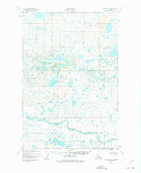
The King Salmon River meanders across the southern portion of this landscape, its wide basin punctuated by numerous small lakes and tundra ponds. This 1952 field survey captures the territory as it appeared during the mid-century period of strategic mapping by the Army Corps of Engineers and the USGS. The land is largely defined by its intricate hydrological network, with the only signs of human habitation or structural presence being a solitary Cabin located on the north bank of the river and the surveying benchmark at VABM 353 Ramp. The topography is documented with 50-foot contours, illustrating the subtle elevation changes characteristic of the Third Judicial Division in this era.
Find a feature on this map
3 named features on this map. Tap any name to fly to it.
Don’t see what you’re looking for? This feature index may not catch every label — zoom into the map to look around manually.
Map Details
Editions of this 1952 Naknek B-3 Map
Other maps of this area

1951 · Naknek A-2
USGS Topo · 1:63,360

1951 · Naknek A-4
USGS Topo · 1:63,360

1951 · Naknek A-3
USGS Topo · 1:63,360

1952 · Naknek
USGS Topo · 1:250,000

1952 · Naknek B-4
USGS Topo · 1:63,360

1952 · Naknek B-2
USGS Topo · 1:63,360

1952 · Naknek C-2
USGS Topo · 1:63,360

1952 · Naknek C-3
USGS Topo · 1:63,360

1952 · Naknek C-4
USGS Topo · 1:63,360

1964 · Naknek
USGS Topo · 1:250,000