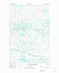
1952 Map of Naknek B-3
USGS Topo · Published 1975About this map
The King Salmon River dominates the southern landscape of this 1952 topographic study, winding through an intricate network of wetlands and tundra ponds typical of the Alaska Peninsula. Mapped by the Army Map Service and later revised for civil use, the terrain is characterized by hundreds of unnamed water bodies and subtle elevation changes across the coastal plain. A single Cabin is marked along the northern bank of the river, representing one of the few signs of human habitation or seasonal shelter in this isolated region during the early fifties. The map provides a precise record of the river's complex meandering patterns and the surrounding glacial topography before more modern development in the wider Naknek area.
Find a feature on this map
2 named features on this map. Tap any name to fly to it.
Don’t see what you’re looking for? This feature index may not catch every label — zoom into the map to look around manually.
Map Details
Editions of this 1952 Naknek B-3 Map
Other maps of this area

1951 · Naknek A-2
USGS Topo · 1:63,360

1951 · Naknek A-4
USGS Topo · 1:63,360

1951 · Naknek A-3
USGS Topo · 1:63,360

1952 · Naknek
USGS Topo · 1:250,000

1952 · Naknek B-3
USGS Topo · 1:63,360

1952 · Naknek B-4
USGS Topo · 1:63,360

1952 · Naknek B-2
USGS Topo · 1:63,360

1952 · Naknek C-2
USGS Topo · 1:63,360

1952 · Naknek C-3
USGS Topo · 1:63,360

1952 · Naknek C-4
USGS Topo · 1:63,360