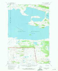
1951 Map of Naknek C-1
USGS Topo · Published 1971About this map
Naknek Lake dominates this mid-century topographic record, particularly its sweeping North Arm which reaches deep into the Alaskan wilderness. The map captures a significant portion of the Naknek National Monument, documenting the terrain before major shifts in park designation and administration. The landscape is defined by the intersection of the Bristol Bay Borough line and the National Monument Boundary (Approximate), marking a transition from municipal administration to protected federal lands. Elevations and landforms throughout the Katmai area were interpreted from 1951 aerial photography, showing a complex network of wetlands and small lakes that characterize this subarctic environment. The survey remains a primary source for researchers studying the historical boundaries and natural state of the peninsula prior to modern infrastructure or more recent geological changes in the region.
Find a feature on this map
6 named features on this map. Tap any name to fly to it.
Don’t see what you’re looking for? This feature index may not catch every label — zoom into the map to look around manually.
Map Details
Editions of this 1951 Naknek C-1 Map
3 editions found
Other maps of this area

1948 · Mt Katmai
USGS Topo · 1:250,000

1951 · Mt Katmai
USGS Topo · 1:250,000

1951 · Mount Katmai C-6
USGS Topo · 1:63,360

1951 · Mount Katmai B-6
USGS Topo · 1:63,360

1951 · Naknek D-1
USGS Topo · 1:63,360

1951 · Naknek B-1
USGS Topo · 1:63,360

1951 · Naknek C-1
USGS Topo · 1:63,360

1951 · Mount Katmai D-6
USGS Topo · 1:63,360

1952 · Naknek
USGS Topo · 1:250,000

1952 · Naknek D-2
USGS Topo · 1:63,360