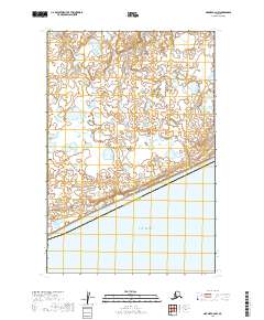
2019 Map of Naknek C-6 NW
USGS Topo · Published 2019About this map
Kvichak Bay dominates the southern portion of this landscape, where the waters of the estuary meet the low-lying coastal terrain of southwest Alaska. The boundary between the Dillingham Census Area and Bristol Bay Borough cuts diagonally across the shoreline, marking a significant administrative division in this sparsely populated region. This 2019 survey illustrates a complex network of small ponds and wetlands typical of the coastal tundra, reflecting the intricate hydrology of the Bristol Bay watershed. The topography remains exceptionally flat, with subtle contour variations revealing the delicate drainage patterns that feed into the bay. This map provides a precise record of the shoreline and internal boundaries within the Public Land Survey System, including townships such as t17s r52w and t17s r53w, which are essential for understanding land divisions in this part of the state.
Find a feature on this map
7 named features on this map. Tap any name to fly to it.
Don’t see what you’re looking for? This feature index may not catch every label — zoom into the map to look around manually.
Map Details
Editions of this 2019 Naknek C-6 NW Map
This is the sole edition of this map. No revisions or reprints were ever made.
Other maps of this area

1945 · Nushagak Bay
USGS Topo · 1:250,000

1949 · Nushagak Bay
USGS Topo · 1:250,000

1951 · Nushagak Bay
USGS Topo · 1:250,000

1952 · Naknek
USGS Topo · 1:250,000
1952 · Nushagak Bay C-1
USGS Topo · 1:63,360

1952 · Naknek C-6
USGS Topo · 1:63,360

1952 · Nushagak Bay D-1
USGS Topo · 1:63,360

1952 · Naknek D-6
USGS Topo · 1:63,360

1964 · Nushagak Bay
USGS Topo · 1:250,000

1964 · Naknek
USGS Topo · 1:250,000