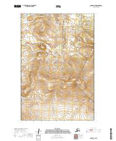
2019 Map of Naknek D-1 NE
USGS Topo · Published 2019About this map
Alagnak Wild River flows through the northern reaches of this territory, where the interior wilderness of the Alaska Peninsula meets the protected landscapes of the Katmai National Preserve. This 2019 survey documents a vast expanse of undeveloped terrain within the Lake and Peninsula Borough, characterized by high-elevation contours and the intricate drainage patterns of the Bristol Bay watershed. The boundary of the Katmai National Preserve occupies the eastern and northeastern portions of the map, marking a transition between federally protected wilderness zones. For those studying the environmental management and remote geography of southern Alaska, this sheet provides a contemporary record of land divisions, including Township 14 South, Range 40 West, and the surrounding survey blocks that define the region's modern cadastral layout.
Find a feature on this map
8 named features on this map. Tap any name to fly to it.
Don’t see what you’re looking for? This feature index may not catch every label — zoom into the map to look around manually.
Map Details
Editions of this 2019 Naknek D-1 NE Map
This is the sole edition of this map. No revisions or reprints were ever made.
Other maps of this area

1948 · Mt Katmai
USGS Topo · 1:250,000

1951 · Dillingham
USGS Topo · 1:250,000

1951 · Mt Katmai
USGS Topo · 1:250,000

1951 · Naknek D-1
USGS Topo · 1:63,360

1951 · Mount Katmai D-6
USGS Topo · 1:63,360

1951 · Iliamna A-8
USGS Topo · 1:63,360

1951 · Dillingham A-1
USGS Topo · 1:63,360

1952 · Iliamna
USGS Topo · 1:250,000

1952 · Naknek
USGS Topo · 1:250,000
1952 · Iliamna A-8
USGS Topo · 1:63,360