
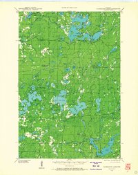
1943 Map of Namekagon Lake
USGS Topo · Published 1960About this map
Namekagon Lake and its intricate network of surrounding waters define this 1943 study of the Northwoods. The landscape is characterized by its glacial lakes and a developing system of forest roads and trails, such as T Tr 90 L and T Tr 84 L, weaving through the National Forest. Scattered social landmarks like the Spider Lake Sch, West Fork Sch, and the Lost Land Lake Club suggest a seasonal and local population centered on the region's natural resources. Water management and conservation are evident through features like the Tiger Cat Dam, West Fork Dam, and the Sawyer CCC Camp. From the heights of the West Fork Fire Tower to the remote shores of Ghost Lake, the map documents a transitional era of forestry and recreation in Sawyer and Bayfield Counties.
Find a feature on this map
98 named features on this map. Tap any name to fly to it.
Don’t see what you’re looking for? This feature index may not catch every label — zoom into the map to look around manually.
Map Details
Editions of this 1943 Namekagon Lake Map
2 editions found
Other maps of this area

1942 · Clam Lake
USGS Topo · 1:48,000

1942 · Marengo
USGS Topo · 1:48,000

1944 · Draper
USGS Topo · 1:48,000

1944 · Couderay
USGS Topo · 1:48,000

1944 · Radisson
USGS Topo · 1:48,000

1944 · Drummond
USGS Topo · 1:48,000

1944 · Grandview
USGS Topo · 1:48,000

1944 · Hayward
USGS Topo · 1:48,000

1945 · Namekagon Lake
USGS Topo · 1:48,000

1945 · Marengo
USGS Topo · 1:48,000