
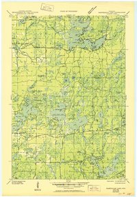
1945 Map of Namekagon Lake
USGS Topo · Published 1945About this map
Namekagon Lake and its intricate shoreline of bays and points dominate the northern landscape of this Chequamegon region as it appeared in the mid-1940s. The settlement at Bergundy and the Lost Land Lake Club serve as early recreational markers in an area still heavily defined by the National Forest boundary and active resource management. The map reveals a network of fire roads and trails, such as T Tr 92 L Trunk, alongside localized infrastructure including the West Fork Fire Tower and the Sawyer CCC Camp in the southeast. Education and industry are evidenced by the Spider Lake Sch and water control structures like Tiger Cat Dam and West Fork Dam. The intricate hydrography of the Namekagon River and numerous smaller basins like Ghost Lake and Mumms Bay illustrate a wilderness being mapped for conservation and early tourism.
Find a feature on this map
110 named features on this map. Tap any name to fly to it.
Don’t see what you’re looking for? This feature index may not catch every label — zoom into the map to look around manually.
Map Details
Editions of this 1945 Namekagon Lake Map
2 editions found
Other maps of this area

1942 · Clam Lake
USGS Topo · 1:48,000

1942 · Marengo
USGS Topo · 1:48,000

1943 · Namekagon Lake
USGS Topo · 1:48,000

1944 · Draper
USGS Topo · 1:48,000

1944 · Couderay
USGS Topo · 1:48,000

1944 · Radisson
USGS Topo · 1:48,000

1944 · Drummond
USGS Topo · 1:48,000

1944 · Grandview
USGS Topo · 1:48,000

1944 · Hayward
USGS Topo · 1:48,000

1945 · Marengo
USGS Topo · 1:48,000