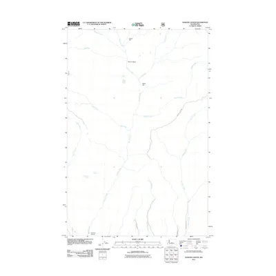
2011 Map of Naneum Canyon
USGS Topo · Published 2011About this map
Naneum Canyon defines this high-elevation landscape in the eastern Cascades foothills during the early twenty-first century. The area is characterized by a complex network of drainages and upland plateaus, where Naneum Creek carves through the central basin. The drainage pattern is dense, including Schnebly Creek, Coleman Creek, and Boulder Creek, which feed into the larger canyon system. Human geography is represented primarily by isolated forest roads and named watering points like Leonard Spring and Gustafson Spring. These features, along with the broad expanses of Croker Flat and Walter Flat, suggest a terrain primarily utilized for timber management, livestock grazing, or seasonal recreation. The lack of concentrated settlements highlights the primitive nature of the road network, including Dawson Canyon Rd and Charlton Rd, which navigate the deep ravines and basins.
Find a feature on this map
19 named features on this map. Tap any name to fly to it.
Don’t see what you’re looking for? This feature index may not catch every label — zoom into the map to look around manually.
Map Details
Editions of this 2011 Naneum Canyon Map
This is the sole edition of this map. No revisions or reprints were ever made.
Other maps of this area

1897 · Mount Stuart
USGS Topo · 1:125,000

1902 · Mount Stuart
USGS Topo · 1:125,000

1913 · Wenatchee
USGS Topo · 1:62,500

1915 · Wenatchee
USGS Topo · 1:62,500

1920 · Colockum Pass
USGS Topo · 1:125,000

1922 · Colockum Pass
USGS Topo · 1:125,000

1957 · Wenatchee
USGS Topo · 1:250,000

1958 · Thorp
USGS Topo · 1:62,500
1958 · Ellensburg North
USGS Topo · 1:24,000

1961 · Liberty
USGS Topo · 1:62,500