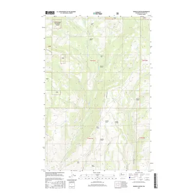
2017 Map of Naneum Canyon
USGS Topo · Published 2017About this map
Wenatchee National Forest occupies the northwestern corner of this territory, where the terrain transitions from high plateaus into deep drainage systems. The landscape is defined by a series of significant erosional features, most notably the winding path of Naneum Canyon and the surrounding Naneum Basin. Higher elevations are marked by distinct level areas such as Croker Flat and Walter Flat, which stand in contrast to the steep descents into Schnebly Canyon and Dawson Canyon. Reliable water sources like Leonard Spring and Gustafson Spring are noted along the western slopes. The map traces a network of resource and access roads, including Schnebly Rd and Dawson Canyon Rd, which navigate the complex topography of Charlton Canyon and Burnt Canyon in the south.
Find a feature on this map
32 named features on this map. Tap any name to fly to it.
Don’t see what you’re looking for? This feature index may not catch every label — zoom into the map to look around manually.
Map Details
Editions of this 2017 Naneum Canyon Map
This is the sole edition of this map. No revisions or reprints were ever made.
Other maps of this area

1897 · Mount Stuart
USGS Topo · 1:125,000

1902 · Mount Stuart
USGS Topo · 1:125,000

1913 · Wenatchee
USGS Topo · 1:62,500

1915 · Wenatchee
USGS Topo · 1:62,500

1920 · Colockum Pass
USGS Topo · 1:125,000

1922 · Colockum Pass
USGS Topo · 1:125,000

1957 · Wenatchee
USGS Topo · 1:250,000

1958 · Thorp
USGS Topo · 1:62,500
1958 · Ellensburg North
USGS Topo · 1:24,000

1961 · Liberty
USGS Topo · 1:62,500