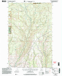
2003 Map of Naneum Canyon
USGS Topo · Published 2006About this map
Naneum Canyon carves a deep path through the Kittitas landscape, serving as a central geological feature within this 2003 revision. The area is defined by its conservation and forestry management, split between the Wenatchee National Forest to the west and the Colockum State Wildlife Area to the east. Water management and resource access are primary themes, evidenced by the Gaging Station Filtration Plant near Naneum Creek and a network of 4wd tracks and the Burnt Trail providing access to the higher elevations.
Find a feature on this map
23 named features on this map. Tap any name to fly to it.
Don’t see what you’re looking for? This feature index may not catch every label — zoom into the map to look around manually.
Map Details
Editions of this 2003 Naneum Canyon Map
This is the sole edition of this map. No revisions or reprints were ever made.
Other maps of this area

1897 · Mount Stuart
USGS Topo · 1:125,000

1902 · Mount Stuart
USGS Topo · 1:125,000

1913 · Wenatchee
USGS Topo · 1:62,500

1915 · Wenatchee
USGS Topo · 1:62,500

1920 · Colockum Pass
USGS Topo · 1:125,000

1922 · Colockum Pass
USGS Topo · 1:125,000

1957 · Wenatchee
USGS Topo · 1:250,000

1958 · Thorp
USGS Topo · 1:62,500
1958 · Ellensburg North
USGS Topo · 1:24,000

1961 · Liberty
USGS Topo · 1:62,500