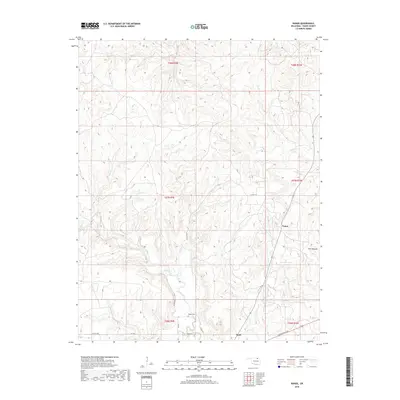
2018 Map of Nanos
USGS Topo · Published 2018About this map
Pappin Cem lies in the southern reaches of this Osage County landscape, nestled near the drainage of Sand Creek. The terrain is defined by a dense network of intermittent watercourses, including Wild Hog Cr, Mud Cr, and Cedar Cr, which carve through the Oklahoma prairie. The small settlements of Nanos and Opah serve as primary anchors for the area's rural road network, which is dominated by routes such as Bartlesville Rd and Co Rd 4220. To the east, the distinct elevation of Twin Mounds stands out as a prominent landmark. This topographic study reflects the modern rural character of the region, where land use is dictated by the deeply etched creek beds and the section lines of the Public Land Survey System, including T27N R9E and T27N R10E.
Find a feature on this map
26 named features on this map. Tap any name to fly to it.
Don’t see what you’re looking for? This feature index may not catch every label — zoom into the map to look around manually.
Map Details
Editions of this 2018 Nanos Map
This is the sole edition of this map. No revisions or reprints were ever made.
Other maps of this area

1906 · Nelagoney
USGS Topo · 1:24,000

1909 · Pawhuska
USGS Topo · 1:125,000

1910 · Pawhuska
USGS Topo · 1:125,000

1955 · Enid
USGS Topo · 1:250,000

1958 · Enid
USGS Topo · 1:250,000

1960 · Nanos
USGS Topo · 1:24,000

1960 · Nelagoney
USGS Topo · 1:24,000

1960 · Herd
USGS Topo · 1:24,000

1960 · Pawhuska
USGS Topo · 1:24,000
1973 · Pearsonia
USGS Topo · 1:24,000