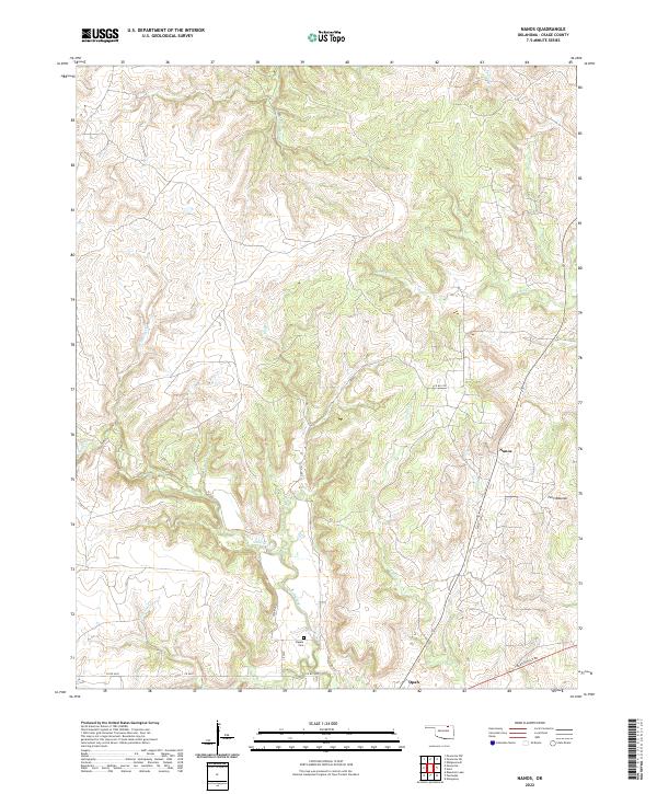
2022 Map of Nanos
USGS Topo · Published 2022About this map
Nanos and the small settlement of Opah anchor this study of the northern Oklahoma landscape in Osage County. The terrain is defined by a dense network of drainages, including Wild Hog Cr, Mud Cr, and Cedar Cr, which carve through the land between distinctive landmarks like the Twin Mounds. The survey captures the rural character of the region as it exists in the early 2020s, showing a transition from these natural watercourses to the straight-line grid of the Public Land Survey System, marked by designations such as t27n r9e. Local history and family heritage are preserved at the Pappin Cem, located near Sand Cr. The southern portion of the area is transacted by Bartlesville Rd, providing a key connection through the prairie and creek-cut valleys.
Find a feature on this map
26 named features on this map. Tap any name to fly to it.
Don’t see what you’re looking for? This feature index may not catch every label — zoom into the map to look around manually.
Map Details
Editions of this 2022 Nanos Map
This is the sole edition of this map. No revisions or reprints were ever made.
Other maps of this area

1906 · Nelagoney
USGS Topo · 1:24,000

1909 · Pawhuska
USGS Topo · 1:125,000

1910 · Pawhuska
USGS Topo · 1:125,000

1955 · Enid
USGS Topo · 1:250,000

1958 · Enid
USGS Topo · 1:250,000

1960 · Nanos
USGS Topo · 1:24,000

1960 · Nelagoney
USGS Topo · 1:24,000

1960 · Herd
USGS Topo · 1:24,000

1960 · Pawhuska
USGS Topo · 1:24,000
1973 · Pearsonia
USGS Topo · 1:24,000