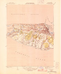
1945 Map of Nantucket
USGS Topo · Published 1945About this map
Nantucket island life in the early 1940s is defined here by its intricate relationship with the water, from the harbor jetties to the inland kettle ponds and marshes. The town core shows a dense street grid featuring the Cyrus Pierce Sch and several burial grounds, including the Old North Cem and Old South Cem. Moving west, the landscape opens into grazing lands like Ram Pasture and isolated settlements such as Maddaket and Warren Landing.
Find a feature on this map
71 named features on this map. Tap any name to fly to it.
Don’t see what you’re looking for? This feature index may not catch every label — zoom into the map to look around manually.
Map Details
Editions of this 1945 Nantucket Map
2 editions found
Other maps of this area

1887 · Muskeget
USGS Topo · 1:62,500

1889 · Muskeget
USGS Topo · 1:62,500

1889 · Nantucket
USGS Topo · 1:62,500

1893 · Nantucket
USGS Topo · 1:62,500

1893 · Muskeget
USGS Topo · 1:62,500

1899 · Muskeget
USGS Topo · 1:62,500

1901 · Nantucket
USGS Topo · 1:62,500

1942 · Nantucket
USGS Topo · 1:125,000

1944 · Tuckernuck Island
USGS Topo · 1:31,680

1945 · Nantucket
USGS Topo · 1:31,680