
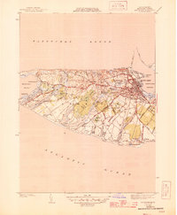
1945 Map of Nantucket
USGS Topo · Published 1945About this map
Nantucket town sits as the primary hub of activity on this mid-century coastal survey, its dense grid of streets like Orange St and Pleasant St leading toward the busy docks of Nantucket Harbor. The surrounding landscape is dominated by a complex network of glacial ponds and wetlands, from the expansive Hummock Pond and Long Pond to the curiously named Rotten Pumpkin Pond. This period captures the island's transition as old roads like Maddaket Road connect the main town to smaller outposts like Maddaket and Warren Landing.
Find a feature on this map
73 named features on this map. Tap any name to fly to it.
Don’t see what you’re looking for? This feature index may not catch every label — zoom into the map to look around manually.
Map Details
Editions of this 1945 Nantucket Map
2 editions found
Other maps of this area

1887 · Muskeget
USGS Topo · 1:62,500

1889 · Muskeget
USGS Topo · 1:62,500

1889 · Nantucket
USGS Topo · 1:62,500

1893 · Nantucket
USGS Topo · 1:62,500

1893 · Muskeget
USGS Topo · 1:62,500

1899 · Muskeget
USGS Topo · 1:62,500

1901 · Nantucket
USGS Topo · 1:62,500

1942 · Nantucket
USGS Topo · 1:125,000

1944 · Tuckernuck Island
USGS Topo · 1:31,680

1945 · Siasconset
USGS Topo · 1:31,680