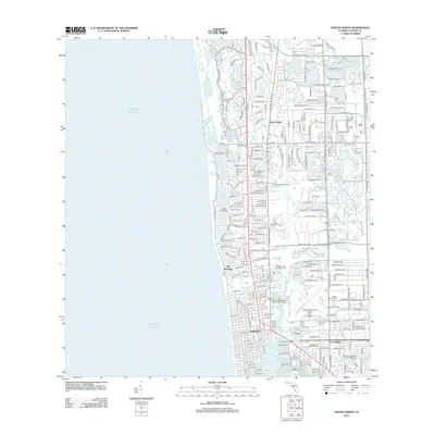
2012 Map of Naples North
USGS Topo · Published 2012About this map
The Gulf of Mexico coastline defines the character of this Collier County region, where intricate coastal waterways like Inner Clam Bay, Hurricane Harbor, and Inner Doctors Bay meet the growing suburban developments of southwest Florida. The map documents the residential patterns of North Naples and the well-established neighborhood of The Moorings, showing a landscape heavily shaped by canal systems and coastal access points such as Crayton Cove.
Find a feature on this map
34 named features on this map. Tap any name to fly to it.
Don’t see what you’re looking for? This feature index may not catch every label — zoom into the map to look around manually.
Map Details
Editions of this 2012 Naples North Map
This is the sole edition of this map. No revisions or reprints were ever made.
Other maps of this area

1956 · West Palm Beach
USGS Topo · 1:250,000

1957 · West Palm Beach
USGS Topo · 1:250,000

1958 · West Palm Beach
USGS Topo · 1:250,000

1958 · Bonita Springs
USGS Topo · 1:24,000

1958 · Belle Meade
USGS Topo · 1:24,000

1958 · Naples South
USGS Topo · 1:24,000

1958 · Belle Meade NW
USGS Topo · 1:24,000

1958 · Corkscrew SW
USGS Topo · 1:24,000

1958 · Naples North
USGS Topo · 1:24,000
1985 · Naples
USGS Topo · 1:100,000