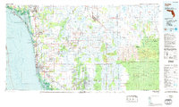
1985 Map of Naples
USGS Topo · Published 1986About this map
The Gulf Coast shoreline from Fort Myers Beach down to Naples defines the western edge of this 1985 topographic-bathymetric survey. While coastal developments like Naples Park and North Naples show significant density, the interior quickly transitions into the massive wetlands of the Big Cypress National Preserve and the Fakahatchee Strand State Preserve. This era captures the region as inland communities like Golden Gate and Immokalee grew alongside critical conservation areas like the Corkscrew Swamp Sanctuary. The landscape is a complex network of sloughs and strands, including Deep Slough and Okaloacoochee Slough, intersected by the Everglades Parkway and the Seaboard Coast Line railroad. Farther east, the Seminole Indian Reservation sits within the expanse of the Big Cypress, illustrating the proximity of managed wilderness and traditional lands during Florida's late 20th-century expansion.
Find a feature on this map
50 named features on this map. Tap any name to fly to it.
Don’t see what you’re looking for? This feature index may not catch every label — zoom into the map to look around manually.
Map Details
Editions of this 1985 Naples Map
2 editions found
Other maps of this area

1956 · Miami
USGS Topo · 1:250,000

1956 · West Palm Beach
USGS Topo · 1:250,000

1956 · Tampa
USGS Topo · 1:250,000

1956 · Charlotte Harbor
USGS Topo · 1:250,000

1957 · West Palm Beach
USGS Topo · 1:250,000

1958 · West Palm Beach
USGS Topo · 1:250,000

1958 · Miami
USGS Topo · 1:250,000

1958 · Corkscrew SE
USGS Topo · 1:24,000

1958 · Bonita Springs
USGS Topo · 1:24,000

1958 · Belle Meade
USGS Topo · 1:24,000