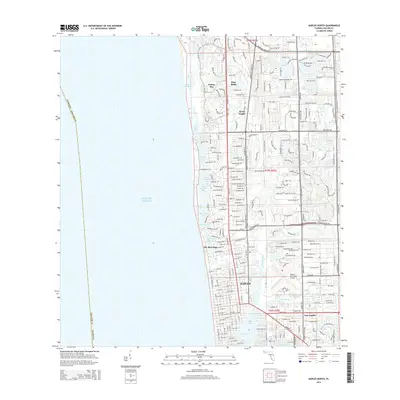
2015 Map of Naples North
USGS Topo · Published 2015About this map
Naples serves as the focal point of this coastal survey, where the urban grid meets the intricate waterways of the Gulf shore. The landscape is defined by its transition from the developed residential corridors of North Naples and Pelican Bay to the natural and engineered inlets of the coast. Distinct neighborhoods like The Moorings and Pine Ridge are clearly delineated alongside the expansive Naples Municipal Airport. Along the shoreline, a complex network of coastal features such as Clam Pass, Venetian Bay, and Hurricane Harbor illustrates the unique hydrology of the region. To the south, East Naples and Crayton Cove mark the transition toward Naples Bay, showing how the city has integrated its growth with the surrounding marine environment and tidal tributaries like the Gordon River.
Find a feature on this map
34 named features on this map. Tap any name to fly to it.
Don’t see what you’re looking for? This feature index may not catch every label — zoom into the map to look around manually.
Map Details
Editions of this 2015 Naples North Map
This is the sole edition of this map. No revisions or reprints were ever made.
Other maps of this area

1956 · West Palm Beach
USGS Topo · 1:250,000

1957 · West Palm Beach
USGS Topo · 1:250,000

1958 · West Palm Beach
USGS Topo · 1:250,000

1958 · Bonita Springs
USGS Topo · 1:24,000

1958 · Belle Meade
USGS Topo · 1:24,000

1958 · Naples South
USGS Topo · 1:24,000

1958 · Belle Meade NW
USGS Topo · 1:24,000

1958 · Corkscrew SW
USGS Topo · 1:24,000

1958 · Naples North
USGS Topo · 1:24,000
1985 · Naples
USGS Topo · 1:100,000