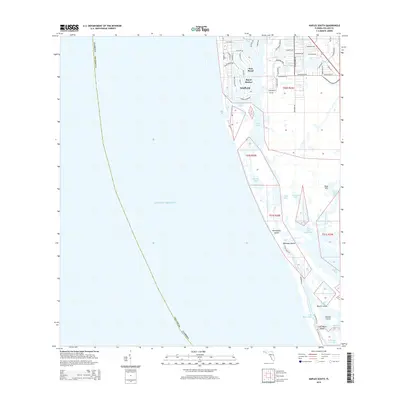
2015 Map of Naples South
USGS Topo · Published 2015About this map
Port Royal and the southern waterfront of Naples anchor this coastal survey, where the developed grids of Royal Harbor meet the intricate mangrove shorelines of the western Everglades. The map captures a landscape defined by water and land reclamation, from the residential canals along Naples Bay to the protected wildness of Rookery Bay and Shell Bay. Navigational features like Gordon Pass and the Calhoun Channel illustrate the vital connection between the mainland and the Gulf of Mexico. Moving south, the terrain shifts from the urban footprint of Naples to a complex archipelago of barrier islands including Keewaydin Island, Halloway Island, and Little Marco Island. This 2015 perspective shows the modern balance between high-end coastal real estate and the preservation of the Sand Hill and Munlin Creek ecosystems.
Find a feature on this map
63 named features on this map. Tap any name to fly to it.
Don’t see what you’re looking for? This feature index may not catch every label — zoom into the map to look around manually.
Map Details
Editions of this 2015 Naples South Map
This is the sole edition of this map. No revisions or reprints were ever made.
Other maps of this area

1956 · Miami
USGS Topo · 1:250,000

1956 · West Palm Beach
USGS Topo · 1:250,000

1957 · West Palm Beach
USGS Topo · 1:250,000

1958 · West Palm Beach
USGS Topo · 1:250,000

1958 · Miami
USGS Topo · 1:250,000

1958 · Belle Meade
USGS Topo · 1:24,000

1958 · Naples South
USGS Topo · 1:24,000

1958 · Belle Meade NW
USGS Topo · 1:24,000

1958 · Naples North
USGS Topo · 1:24,000

1973 · Marco Island
USGS Topo · 1:24,000