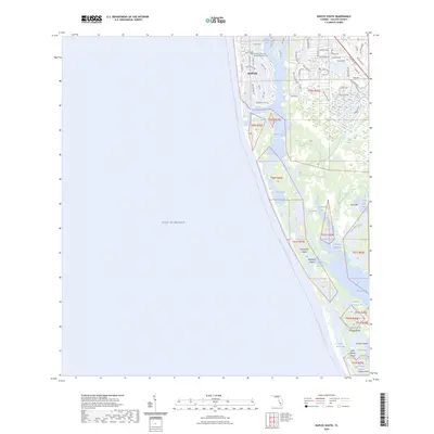
2024 Map of Naples South
USGS Topo · Published 2024About this map
The coastal transition from the established community of Naples southward into the intricate barrier islands and estuaries of Collier County is documented in this contemporary survey. Residential streets like Fort Charles Dr and Rum Row sit nestled against the water, centered around the Trinity By The Cove Episcopal Church Cem. South of Gordon Pass, the landscape shifts toward a labyrinth of protected waters and undeveloped islands. The extensive Florida Circumnavigational Paddling Trl winds through Dollar Bay and past Keewaydin Island, illustrating the region's importance for maritime recreation and conservation. Names like Halloway Island, Munlin Island, and Cannon Island define a territory where mangroves and tidal channels like Rookery Channel predominate, providing a detailed record of the shoreline before the southern reaches of the Gulf of Mexico.
Find a feature on this map
62 named features on this map. Tap any name to fly to it.
Don’t see what you’re looking for? This feature index may not catch every label — zoom into the map to look around manually.
Map Details
Editions of this 2024 Naples South Map
This is the sole edition of this map. No revisions or reprints were ever made.
Other maps of this area

1956 · Miami
USGS Topo · 1:250,000

1956 · West Palm Beach
USGS Topo · 1:250,000

1957 · West Palm Beach
USGS Topo · 1:250,000

1958 · West Palm Beach
USGS Topo · 1:250,000

1958 · Miami
USGS Topo · 1:250,000

1958 · Belle Meade
USGS Topo · 1:24,000

1958 · Naples South
USGS Topo · 1:24,000

1958 · Belle Meade NW
USGS Topo · 1:24,000

1958 · Naples North
USGS Topo · 1:24,000

1973 · Marco Island
USGS Topo · 1:24,000