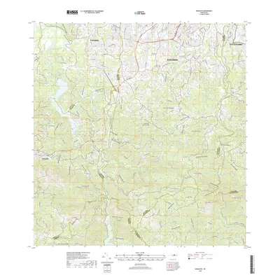
2018 Map of Naranjito
USGS Topo · Published 2018About this map
Naranjito and the surrounding hills of the Island of Puerto Rico are defined by a complex network of canyons and ridges in this 2018 topographic study. The landscape transitions from the suburban density of Pájaros and Bayamón in the north to the more mountainous terrain of the south, where numerous 'quebradas' or creeks drain into the Rio de la Plata and Rio de Bayamón. Navigating these ridges are major thoroughfares like Ave Las Cumbres and Ave Comerio, which connect the interior settlements. Local landmarks such as the Cementerio Los Cipreses and prominent peaks like Cerro de Vergara and Cerro Avispa provide a clear view of the area's development and natural contours. The map effectively documents the intersection of municipal boundaries, including the lines between Toa Alta Naranjito and Bayamón Guaynabo, during a period of sustained growth.
Find a feature on this map
56 named features on this map. Tap any name to fly to it.
Don’t see what you’re looking for? This feature index may not catch every label — zoom into the map to look around manually.
Map Details
Editions of this 2018 Naranjito Map
This is the sole edition of this map. No revisions or reprints were ever made.
Other maps of this area

1940 · Vega Alta
USGS Topo · 1:30,000

1941 · Bayamon
USGS Topo · 1:30,000

1941 · San Juan
USGS Topo · 1:30,000

1946 · Aguas Buenas
USGS Topo · 1:30,000

1946 · Corozal
USGS Topo · 1:30,000

1946 · Barranquitas
USGS Topo · 1:30,000

1946 · Vega Alta
USGS Topo · 1:30,000

1946 · Comerio
USGS Topo · 1:30,000

1946 · Naranjito
USGS Topo · 1:30,000

1946 · Caguas
USGS Topo · 1:30,000
Featured Places
- Naranjito
- Villas del Olimpo, Bayamón
- Sector Pellín Ortega, Bayamón
- Sector Los Falcones, Bayamón
- Sector Flor Sánchez, Bayamón