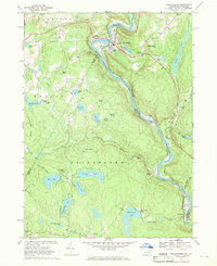
1968 Map of Narrowsburg
USGS Topo · Published 1969About this map
Narrowsburg and the winding Delaware River anchor this late-1960s survey along the New York and Pennsylvania border. The village is a focal point of activity, featuring the St Francis Ch, Glen Cove Cem, and a nearby Landing Strip. On the Pennsylvania side, the landscape is defined by the Erie-Lackawanna railroad following the river’s curve, passing through Tusten Station and Tusten.
Find a feature on this map
66 named features on this map. Tap any name to fly to it.
Don’t see what you’re looking for? This feature index may not catch every label — zoom into the map to look around manually.
Map Details
Editions of this 1968 Narrowsburg Map
Other maps of this area

1913 · Milford
USGS Topo · 1:62,500

1915 · Milford
USGS Topo · 1:62,500

1920 · Damascus
USGS Topo · 1:62,500

1922 · White Lake
USGS Topo · 1:62,500

1923 · Damascus
USGS Topo · 1:62,500

1935 · Hawley
USGS Topo · 1:62,500

1938 · Hawley
USGS Topo · 1:62,500

1942 · White Lake
USGS Topo · 1:62,500

1943 · Honesdale
USGS Topo · 1:125,000

1943 · White Lake
USGS Topo · 1:62,500