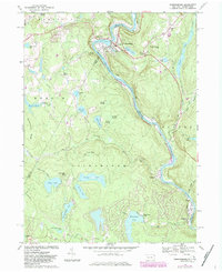
1968 Map of Narrowsburg
USGS Topo · Published 1983About this map
Narrowsburg and the winding corridor of the Upper Delaware River define this river-valley landscape during the late 1960s. The region shows a dense network of water bodies and recreational camps, from Luxton Lake in the northeast to Wolf Lake and Teedyuskung Lake in the southwest. Transport and industry follow the river's curve, with the Conrail line hugging the eastern bank past Tusten Station and Darbytown. Local history is anchored by several rural burial grounds including Glen Cove Cem and Lava Cem, alongside the St Francis Ch in the heart of town. The map documents a geography where logging-era settlements like Tusten transitioned into a summer recreation hub, evident in the numerous camps and parks like Forest Lake Park and Camp Colang.
Find a feature on this map
66 named features on this map. Tap any name to fly to it.
Don’t see what you’re looking for? This feature index may not catch every label — zoom into the map to look around manually.
Map Details
Editions of this 1968 Narrowsburg Map
Other maps of this area

1913 · Milford
USGS Topo · 1:62,500

1915 · Milford
USGS Topo · 1:62,500

1920 · Damascus
USGS Topo · 1:62,500

1922 · White Lake
USGS Topo · 1:62,500

1923 · Damascus
USGS Topo · 1:62,500

1935 · Hawley
USGS Topo · 1:62,500

1938 · Hawley
USGS Topo · 1:62,500

1942 · White Lake
USGS Topo · 1:62,500

1943 · Honesdale
USGS Topo · 1:125,000

1943 · White Lake
USGS Topo · 1:62,500