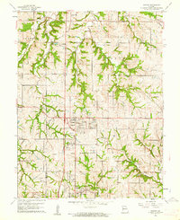
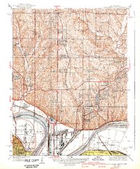
1961 Map of Nashua
USGS Topo · Published 1962About this map
Nashua and Gashland serve as primary anchors in this early 1960s landscape, illustrating the northward expansion of Kansas City across the Platte and Clay County line. The map captures a moment of suburban transition where rural landmarks like Mt Olivet Ch and Gordon Sch coexist with modern mid-century additions, such as the prominent Radio Towers (KCMO) and a Drive-in Theater. The terrain is defined by the winding drainages of Shoal Creek and Second Creek, which break up the geometric section lines of the surrounding townships. Local industrial and community footprints are visible through a Quarry near the western boundary and the Resurrection Cem to the east. This survey provides a clear view of the area's development before the full-scale suburban density of later decades took hold.
Find a feature on this map
24 named features on this map. Tap any name to fly to it.
Don’t see what you’re looking for? This feature index may not catch every label — zoom into the map to look around manually.
Map Details
Editions of this 1961 Nashua Map
4 editions found
Other maps of this area

1890 · Kansas City
USGS Topo · 1:125,000

1894 · Kansas City
USGS Topo · 1:125,000

1894 · Independence
USGS Topo · 1:125,000

1914 · Smithville
USGS Topo · 1:62,500

1935 · North Kansas City
USGS Topo · 1:24,000

1935 · Liberty
USGS Topo · 1:24,000

1936 · Kearney
USGS Topo · 1:48,000

1940 · Liberty
USGS Topo · 1:31,680
1940 · North Kansas City
USGS Topo · 1:31,680

1942 · Kearney
USGS Topo · 1:62,500