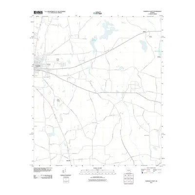
2011 Map of Nashville East
USGS Topo · Published 2011About this map
Nashville anchors the western edge of this Berrien County landscape, which transitions from a town center into an expansive network of rural homesteads and agricultural tracts. The map reveals a high density of small family and community burial grounds, including Old Griner Cemetery, Saint James Cemetery, and Eastview Cemetery, which offer valuable coordinates for genealogists tracing local lineage. The region's aviation and transport infrastructure is represented by the Berrien County Airport and the South One Ten Airport, alongside historic thoroughfares such as Old Coffee Rd N. The terrain is defined by the wandering paths of Tenmile Creek and Wolfpen Branch, which feed into local landmarks like Avery's Millpond and the Gaskins Lake Dam. These watercourses and the grid of county roads connect the outlying communities of Allenville and Weber, illustrating the distributed settlement pattern of southern Georgia in the early 21st century.
Find a feature on this map
62 named features on this map. Tap any name to fly to it.
Don’t see what you’re looking for? This feature index may not catch every label — zoom into the map to look around manually.
Map Details
Editions of this 2011 Nashville East Map
This is the sole edition of this map. No revisions or reprints were ever made.
Other maps of this area

1953 · Waycross
USGS Topo · 1:250,000

1958 · Waycross
USGS Topo · 1:250,000

1968 · Lakeland
USGS Topo · 1:24,000

1972 · Tenmile Bay
USGS Topo · 1:24,000

1972 · Willacoochee
USGS Topo · 1:24,000

1973 · New Lois
USGS Topo · 1:24,000

1973 · Sapps Lake
USGS Topo · 1:24,000

1973 · Nashville West
USGS Topo · 1:24,000
1977 · Hastings Fish Pond
USGS Topo · 1:24,000
1978 · Nashville East
USGS Topo · 1:24,000