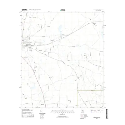
2014 Map of Nashville East
USGS Topo · Published 2014About this map
Nashville anchors the western edge of this Berrien County landscape, showing the residential expansion and local infrastructure in the mid-2010s. The terrain is defined by the winding course of Tenmile Cr and Fivomile Cr, which feed into various wetlands and named basins such as Averys Millpond and Gaskins Lake. The area reflects a rural economy supported by aviation and transit, with the Berrien County Airport situated north of the city and South One Ten Airport further south along the US-129 corridor. This period of development is marked by a network of agricultural and family-named roads like Woody Farm Rd and Marie McGill Rd. For those tracing family histories, several community landmarks are documented, including the Old Griner Cem, Saint James Cem, and the small settlement of Weber in the northeast corner near the Gaskins Cem.
Find a feature on this map
109 named features on this map. Tap any name to fly to it.
Don’t see what you’re looking for? This feature index may not catch every label — zoom into the map to look around manually.
Map Details
Editions of this 2014 Nashville East Map
This is the sole edition of this map. No revisions or reprints were ever made.
Other maps of this area

1953 · Waycross
USGS Topo · 1:250,000

1958 · Waycross
USGS Topo · 1:250,000

1968 · Lakeland
USGS Topo · 1:24,000

1972 · Tenmile Bay
USGS Topo · 1:24,000

1972 · Willacoochee
USGS Topo · 1:24,000

1973 · New Lois
USGS Topo · 1:24,000

1973 · Sapps Lake
USGS Topo · 1:24,000

1973 · Nashville West
USGS Topo · 1:24,000
1977 · Hastings Fish Pond
USGS Topo · 1:24,000
1978 · Nashville East
USGS Topo · 1:24,000