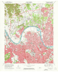
1968 Map of Nashville West
USGS Topo · Published 1971About this map
The Cumberland River carves a deep horseshoe bend around Bordeaux, anchoring this detailed 1960s study of Tennessee's capital. The map captures a period of intense urban and institutional development, evidenced by the sprawling campus footprints of Vanderbilt University, Fisk University, and Meharry Medical College. The downtown core is defined by the State Capitol and Municipal Auditorium, while the surrounding neighborhoods reflect a landscape of historic civic institutions including St Marys Orphanage and the American Theological Seminary.
Find a feature on this map
101 named features on this map. Tap any name to fly to it.
Don’t see what you’re looking for? This feature index may not catch every label — zoom into the map to look around manually.
Map Details
Editions of this 1968 Nashville West Map
4 editions found
Other maps of this area

1903 · Nashville
USGS Topo · 1:125,000

1931 · Ridgetop
USGS Topo · 1:62,500

1932 · Hermitage
USGS Topo · 1:62,500

1932 · Nashville
USGS Topo · 1:62,500

1935 · Ridgetop
USGS Topo · 1:62,500

1942 · Gallatin
USGS Topo · 1:100,000

1942 · Lebanon
USGS Topo · 1:100,000

1952 · Goodlettsville
USGS Topo · 1:24,000

1952 · Nashville West
USGS Topo · 1:24,000

1952 · Nashville East
USGS Topo · 1:24,000