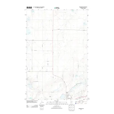
2013 Map of Nashwauk
USGS Topo · Published 2013About this map
Nashwauk and the adjacent settlement of Cooley anchor the southern portion of this Itasca County landscape, where the iron-mining history of the Mesabi Range has fundamentally reshaped the terrain. The presence of the massive Perry-Wyman Tailings Basin in the southeast, alongside the industrial alignment of Us-169, illustrates the heavy earth-moving legacy of the region. North of the town centers, the land is characterized by a network of rural roads such as MN-65 and Co HWY-56, which navigate a dense patchwork of glacial water bodies. From larger basins like Shoal Lake and Harrison Lake to smaller features like Little Mc Carthy Lake, the map documents a transition from industrial activity to the lake-studded wilderness typical of northern Minnesota. Local sites such as the Nashwauk Cem and Nashwauk City Park Camp provide specific points of interest for genealogists and local historians tracking the development of these mining communities in the 21st century.
Find a feature on this map
36 named features on this map. Tap any name to fly to it.
Don’t see what you’re looking for? This feature index may not catch every label — zoom into the map to look around manually.
Map Details
Editions of this 2013 Nashwauk Map
This is the sole edition of this map. No revisions or reprints were ever made.
Other maps of this area

1919 · Release
USGS Topo · 1:62,500

1920 · Trout Lake
USGS Topo · 1:62,500

1943 · Release
USGS Topo · 1:62,500

1952 · Keewatin
USGS Topo · 1:24,000

1952 · Nashwauk
USGS Topo · 1:24,000

1952 · Silica
USGS Topo · 1:24,000

1952 · Calumet
USGS Topo · 1:24,000

1952 · Pengilly
USGS Topo · 1:24,000

1954 · Hibbing
USGS Topo · 1:250,000

1957 · Hibbing
USGS Topo · 1:250,000