
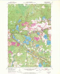
1952 Map of Calumet
USGS Topo · Published 1954About this map
The Iron Range landscape of Itasca County is defined by a massive industrial footprint in this mid-century survey, where the heavy excavation of the Mesabi Range meets the glacial waters of the Swan River valley. Communities like Calumet, Marble, and Taconite are tightly clustered around a series of enormous open pits and associated infrastructure, including the Hill Annex Mine and Arcturus Mine. This era shows the peak of the local mining economy, with a complex network of mine dumps, tailings ponds, and specialized transit lines such as the Hill Annex Mining Railroad and the Duluth Missabe and Iron Range tracks. South of the industrial zone, the terrain transitions into a dense cluster of lakes, including Twin Lakes, Holman Lake, and the northern reaches of Trout Lake, illustrating the sharp contrast between the altered mining lands and the natural Minnesota wilderness.
Find a feature on this map
39 named features on this map. Tap any name to fly to it.
Don’t see what you’re looking for? This feature index may not catch every label — zoom into the map to look around manually.
Map Details
Editions of this 1952 Calumet Map
2 editions found
Other maps of this area

1920 · Trout Lake
USGS Topo · 1:62,500

1952 · Nashwauk
USGS Topo · 1:24,000

1952 · Pengilly
USGS Topo · 1:24,000

1952 · Bovey
USGS Topo · 1:24,000

1954 · Hibbing
USGS Topo · 1:250,000

1957 · Hibbing
USGS Topo · 1:250,000

1958 · Hibbing
USGS Topo · 1:250,000

1964 · Hibbing
USGS Topo · 1:250,000

1969 · La Prairie
USGS Topo · 1:24,000
1969 · Goodland
USGS Topo · 1:24,000