
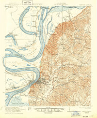
1922 Map of Natchez
USGS Topo · Published 1938About this map
Natchez serves as the focal point of this riverine survey, where the Mississippi River creates a labyrinth of oxbow lakes, islands, and points. The landscape is defined by its plantation heritage, with vast tracts like Windemere, Taconey, and Whitehall bordering the fertile riverbanks. In the hills east of the city, a dense network of country roads including Pine Ridge Road and Washington Road connects smaller settlements and rural institutions like the Daughters of Zion Church and Quitman School.
Find a feature on this map
99 named features on this map. Tap any name to fly to it.
Don’t see what you’re looking for? This feature index may not catch every label — zoom into the map to look around manually.
Map Details
Editions of this 1922 Natchez Map
2 editions found
Other maps of this area

1909 · Sycamore Landing
USGS Topo · 1:24,000

1909 · Vidalia
USGS Topo · 1:24,000

1921 · Natchez
USGS Topo · 1:48,000

1939 · Red Gum
USGS Topo · 1:62,500

1939 · Lorman
USGS Topo · 1:62,500

1939 · Natchez
USGS Topo · 1:62,500

1939 · Kingston
USGS Topo · 1:62,500

1939 · Deer Park
USGS Topo · 1:62,500

1939 · Locust Ridge
USGS Topo · 1:62,500

1941 · Sicily Island
USGS Topo · 1:62,500