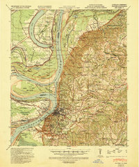
1939 Map of Natchez
USGS Topo · Published 1943About this map
The Mississippi River creates a high-contrast border between the alluvial lowlands of Concordia Parish and the bluffs of Adams County in this pre-war survey. On the western bank, the landscape is dominated by large-scale agricultural operations and oxbow lakes like Lake St John and Lake Concordia, where Alabama Plantation and Canebrake sit amidst a network of levees and river bends. The eastern side of the river reveals a different social geography, with the city of Natchez anchored by the Natchez City Cem and the U S Eng Depot. Scattered throughout the hills are numerous family-named estates such as Longwood Plantation and Hawthorne Plantation, as well as ancient Indian Mounds, illustrating a deep chronology of human occupation. The presence of Oil Wells near the Jefferson Adams County Line signals the industrial shifts beginning to touch this traditional plantation economy.
Find a feature on this map
119 named features on this map. Tap any name to fly to it.
Don’t see what you’re looking for? This feature index may not catch every label — zoom into the map to look around manually.
Map Details
Editions of this 1939 Natchez Map
3 editions found
Other maps of this area

1909 · Sycamore Landing
USGS Topo · 1:24,000

1909 · Vidalia
USGS Topo · 1:24,000

1921 · Natchez
USGS Topo · 1:48,000

1922 · Natchez
USGS Topo · 1:62,500

1939 · Red Gum
USGS Topo · 1:62,500

1939 · Lorman
USGS Topo · 1:62,500

1939 · Natchez
USGS Topo · 1:62,500

1939 · Kingston
USGS Topo · 1:62,500

1939 · Deer Park
USGS Topo · 1:62,500

1939 · Locust Ridge
USGS Topo · 1:62,500