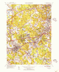
1950 Map of Natick
USGS Topo · Published 1956About this map
Wellesley College and Brandeis University anchor a landscape defined by significant academic and institutional growth during the mid-century era. The Charles River and Sudbury River frame a region transitioning from its agricultural past toward post-war suburban density, particularly visible in the concentrated streets of Natick, Wellesley Hills, and Auburndale. The complex water management systems of the era are prominently displayed, including the Stony Brook Reservoir, Norumbega Reservoir, and Doublet Hill Reservoir, which served the expanding Boston metropolitan area.
Find a feature on this map
95 named features on this map. Tap any name to fly to it.
Don’t see what you’re looking for? This feature index may not catch every label — zoom into the map to look around manually.
Map Details
Editions of this 1950 Natick Map
3 editions found
Other maps of this area

1886 · Dedham
USGS Topo · 1:62,500

1886 · Framingham
USGS Topo · 1:62,500

1887 · Franklin
USGS Topo · 1:62,500

1889 · Franklin
USGS Topo · 1:62,500

1889 · Framingham
USGS Topo · 1:62,500

1893 · Franklin
USGS Topo · 1:62,500

1893 · Boston
USGS Topo · 1:62,500

1894 · Dedham
USGS Topo · 1:62,500

1894 · Framingham
USGS Topo · 1:62,500

1903 · Boston
USGS Topo · 1:62,500