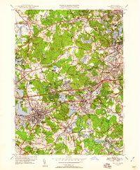
1950 Map of Natick
USGS Topo · Published 1958About this map
The Charles River meanders through this landscape, defining the borders of established academic centers and growing mid-century suburbs. Significant institutions dominate the terrain, including the sprawling grounds of Wellesley College, Regis College, Babson Institute, and Brandeis University. The map documents a period of suburban consolidation, with the Worcester Turnpike and the Boston and Albany RR providing the vital infrastructure for towns like Wellesley, Natick, and Weston. Local life is further evidenced by a high density of community landmarks, from the Morse Hospital to several family and public burial grounds like Farmers Cem and Mt Feake Cem. Water management is a visible priority, shown through the Stony Brook Reservoir and Norumbega Reservoir, which speak to the regional demand for resources as the metropolitan area expanded during the 1940s and 1950s.
Find a feature on this map
88 named features on this map. Tap any name to fly to it.
Don’t see what you’re looking for? This feature index may not catch every label — zoom into the map to look around manually.
Map Details
Editions of this 1950 Natick Map
3 editions found
Other maps of this area

1886 · Dedham
USGS Topo · 1:62,500

1886 · Framingham
USGS Topo · 1:62,500

1887 · Franklin
USGS Topo · 1:62,500

1889 · Franklin
USGS Topo · 1:62,500

1889 · Framingham
USGS Topo · 1:62,500

1893 · Franklin
USGS Topo · 1:62,500

1893 · Boston
USGS Topo · 1:62,500

1894 · Dedham
USGS Topo · 1:62,500

1894 · Framingham
USGS Topo · 1:62,500

1903 · Boston
USGS Topo · 1:62,500