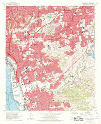
1967 Map of National City
USGS Topo · Published 1970About this map
National City and the surrounding south San Diego suburbs are shown during a period of significant mid-century expansion. The landscape is defined by the canyon-and-mesa topography of Telegraph Canyon and Rice Canyon, which shaped the development of residential neighborhoods like Encanto and Lemon Grove. Vital infrastructure from this era is prominent, including the San Diego and Arizona Eastern Ry and the Naval Radio Sta, alongside the expanding footprint of the South Bay Freeway. Local community life is evidenced by numerous parochial and public schools, such as St Michaels Academy and O'Farrell Jr High Sch. Near the Sweetwater River, industrial activity is marked by Gravel Pits and the Sweetwater Res, while more established civic markers like Holy Cross Cem and the Museum of American Treasures anchor the older urban centers.
Find a feature on this map
102 named features on this map. Tap any name to fly to it.
Don’t see what you’re looking for? This feature index may not catch every label — zoom into the map to look around manually.
Map Details
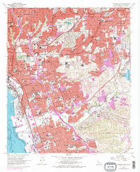
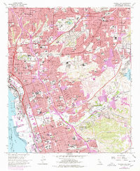
Editions of this 1967 National City Map
3 editions found
Other maps of this area

1893 · El Cajon
USGS Topo · 1:62,500

1901 · Elcajon
USGS Topo · 1:62,500

1903 · Cuyamaca
USGS Topo · 1:125,000

1903 · La Jolla
USGS Topo · 1:62,500

1903 · Elcajon
USGS Topo · 1:62,500

1904 · San Diego
USGS Topo · 1:62,500

1904 · Southern California Sheet No. 2
USGS Topo · 1:250,000

1930 · La Jolla
USGS Topo · 1:62,500

1930 · San Diego
USGS Topo · 1:62,500

1939 · El Cajon
USGS Topo · 1:62,500