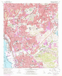
1967 Map of National City
USGS Topo · Published 1978About this map
National City and the surrounding South Bay area are shown here during a period of significant urban expansion, characterized by the dense residential infill and freeway development of the late 1960s and mid-1970s. The landscape is defined by its transit corridors, including the San Diego and Arizona Eastern RR and the San Diego Freeway, which intersect the older street grids of Chula Vista and Lemon Grove. Deep within the canyons, newer developments like Lynwood Hills and Sunny Vista appear alongside established institutions such as the Chollas Heights Naval Radio Sta and St Michaels Academy. The presence of numerous large burial grounds, including Greenwood Cemetery and Mount Hope Cem, provides a detailed record of the region's communal history. Near Sweetwater Res, the map captures the transition from open canyon lands to structured suburban environments.
Find a feature on this map
128 named features on this map. Tap any name to fly to it.
Don’t see what you’re looking for? This feature index may not catch every label — zoom into the map to look around manually.
Map Details
Editions of this 1967 National City Map
3 editions found
Other maps of this area

1893 · El Cajon
USGS Topo · 1:62,500

1901 · Elcajon
USGS Topo · 1:62,500

1903 · Cuyamaca
USGS Topo · 1:125,000

1903 · La Jolla
USGS Topo · 1:62,500

1903 · Elcajon
USGS Topo · 1:62,500

1904 · San Diego
USGS Topo · 1:62,500

1904 · Southern California Sheet No. 2
USGS Topo · 1:250,000

1930 · La Jolla
USGS Topo · 1:62,500

1930 · San Diego
USGS Topo · 1:62,500

1939 · El Cajon
USGS Topo · 1:62,500