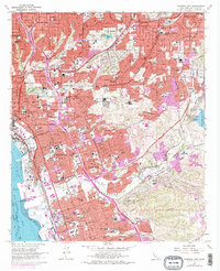
1967 Map of National City
USGS Topo · Published 1978About this map
The San Diego and Arizona Eastern RR winds through a landscape of rapid mid-century suburban expansion, connecting the dense urban cores of San Diego and National City to the eastern hills. The 1970s revisions, noted in purple, document the burgeoning infrastructure of South Bay as residential developments push into Sweetwater Valley and Paradise Valley. Prominent commemorative spaces like Holy Cross Cem, Mount Hope Cemetery, and Greenwood Memorial Park create large green breaks in the residential grid, while specialized sites like the Naval Radio Sta near Chollas Res point to the area's significant military and communications footprint.
Find a feature on this map
111 named features on this map. Tap any name to fly to it.
Don’t see what you’re looking for? This feature index may not catch every label — zoom into the map to look around manually.
Map Details
Editions of this 1967 National City Map
3 editions found
Other maps of this area

1893 · El Cajon
USGS Topo · 1:62,500

1901 · Elcajon
USGS Topo · 1:62,500

1903 · Cuyamaca
USGS Topo · 1:125,000

1903 · La Jolla
USGS Topo · 1:62,500

1903 · Elcajon
USGS Topo · 1:62,500

1904 · San Diego
USGS Topo · 1:62,500

1904 · Southern California Sheet No. 2
USGS Topo · 1:250,000

1930 · La Jolla
USGS Topo · 1:62,500

1930 · San Diego
USGS Topo · 1:62,500

1939 · El Cajon
USGS Topo · 1:62,500