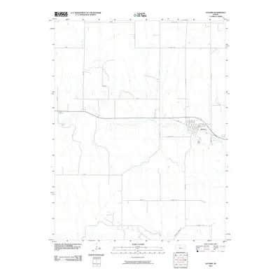
2010 Map of Natoma
USGS Topo · Published 2010About this map
Natoma sits at the junction of several rural arteries in the southeastern corner of Osborne County, serving as the primary hub for this stretch of Kansas prairie. The town's grid is detailed with residential streets such as N 5th St and N 4th St, while the Natoma Cemetery and Conger Cemetery provide significant points of interest for genealogists tracing local family history. The landscape is defined by the winding course of Paradise Creek, which snakes through the center of the map, and Eagle Creek in the northeast, both of which carved the drainages that dictate the local road network. Transport in the early 21st century relied on a system of county roads and named routes like Fairport Natoma Rd, maintaining the agricultural connectivity of the region.
Find a feature on this map
29 named features on this map. Tap any name to fly to it.
Don’t see what you’re looking for? This feature index may not catch every label — zoom into the map to look around manually.
Map Details
Editions of this 2010 Natoma Map
This is the sole edition of this map. No revisions or reprints were ever made.
Other maps of this area

1896 · Osborne
USGS Topo · 1:125,000

1896 · Plainville
USGS Topo · 1:125,000

1955 · Beloit
USGS Topo · 1:250,000

1959 · Beloit
USGS Topo · 1:250,000
1978 · Natoma
USGS Topo · 1:24,000
1978 · Paradise NW
USGS Topo · 1:24,000
1978 · Paradise
USGS Topo · 1:24,000
1978 · Alton SW
USGS Topo · 1:24,000
1978 · Codell
USGS Topo · 1:24,000
1978 · Twin Mound
USGS Topo · 1:24,000