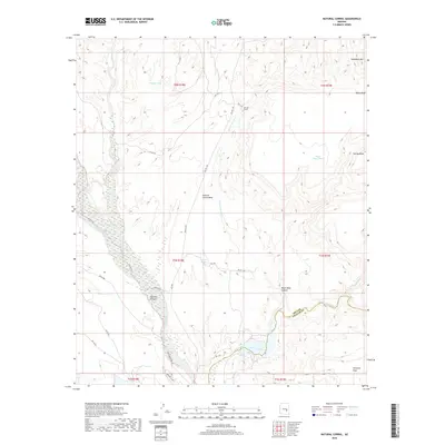
2018 Map of Natural Corral
USGS Topo · Published 2018About this map
Cassadore Mtn and Black Mesa dominate the high ground in this arid reach of eastern Arizona, where the Gila Co Graham Co line divides the landscape. The San Carlos River winds through the southern portion of the quadrangle, joined by the Blue River amidst the level expanse of Antelope Flats. This area is defined by its complex network of seasonal drainages and canyons, including Dourine Canyon and Black Mesa Canyon, which have carved deep into the tablelands.
Find a feature on this map
36 named features on this map. Tap any name to fly to it.
Don’t see what you’re looking for? This feature index may not catch every label — zoom into the map to look around manually.
Map Details
Editions of this 2018 Natural Corral Map
This is the sole edition of this map. No revisions or reprints were ever made.
Other maps of this area

1922 · Chrysotile
USGS Topo · 1:125,000

1954 · Mesa
USGS Topo · 1:250,000

1957 · Mesa
USGS Topo · 1:250,000

1958 · Mesa
USGS Topo · 1:250,000

1960 · Mesa
USGS Topo · 1:250,000

1964 · Mesa
USGS Topo · 1:250,000

1965 · Sontag Mesa
USGS Topo · 1:24,000

1965 · Bucket Mtn
USGS Topo · 1:24,000

1966 · Natural Corral
USGS Topo · 1:24,000
1966 · Dourine Canyon
USGS Topo · 1:24,000