
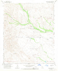
1966 Map of Natural Corral
USGS Topo · Published 1967About this map
The San Carlos Indian Reservation landscape is defined by its arid mesa systems and essential water infrastructure as documented in this mid-1960s survey. Significant drainage networks like Sevenmile Wash and Natural Corral Creek carve through the elevated plains of Natural Corral Mesa and Sontag Mesa. The reliance on local groundwater is evident through a series of named water sources such as Holdup Tank, Smith Well, and Natural Tank, which supported land use before reaching the southern confluence of the San Carlos River and the Blue River. Near the Gila and Graham county boundary, the San Carlos Landing Strip and a Tufa Stone Quarry indicate small-scale industrial and transport developments within the reservation. These features, along with numerous jeep trails, illustrate a period of transition where traditional terrain began meeting modern resource extraction and infrastructure.
Find a feature on this map
31 named features on this map. Tap any name to fly to it.
Don’t see what you’re looking for? This feature index may not catch every label — zoom into the map to look around manually.
Map Details
Editions of this 1966 Natural Corral Map
This is the sole edition of this map. No revisions or reprints were ever made.
Other maps of this area

1922 · Chrysotile
USGS Topo · 1:125,000

1954 · Mesa
USGS Topo · 1:250,000

1957 · Mesa
USGS Topo · 1:250,000

1958 · Mesa
USGS Topo · 1:250,000

1960 · Mesa
USGS Topo · 1:250,000

1964 · Mesa
USGS Topo · 1:250,000

1965 · Sontag Mesa
USGS Topo · 1:24,000

1965 · Bucket Mtn
USGS Topo · 1:24,000
1966 · Dourine Canyon
USGS Topo · 1:24,000

1966 · Cassadore Spring
USGS Topo · 1:24,000