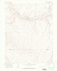
1964 Map of Naturita
USGS Topo · Published 1968About this map
The San Miguel River carves through this landscape, anchoring the mining and agricultural development of western Colorado. The town of Naturita serves as the central hub, flanked by the residential pockets of West Vancorum and East Vancorum. Evidence of mid-century industrial activity is prominent, with various Mines and Mine Tailings located near the riverbank, particularly upstream from the main settlement.
Find a feature on this map
34 named features on this map. Tap any name to fly to it.
Don’t see what you’re looking for? This feature index may not catch every label — zoom into the map to look around manually.
Map Details
Editions of this 1964 Naturita Map
3 editions found
Other maps of this area

1916 · Paradox Valley
USGS Topo · 1:125,000

1922 · Paradox Valley
USGS Topo · 1:125,000

1948 · Uravan
USGS Topo · 1:24,000

1948 · Naturita NW
USGS Topo · 1:24,000

1948 · Gypsum Gap
USGS Topo · 1:24,000

1949 · Gypsum Gap
USGS Topo · 1:24,000

1949 · Uravan
USGS Topo · 1:24,000

1949 · Naturita NW
USGS Topo · 1:24,000

1956 · Moab
USGS Topo · 1:250,000

1959 · Moab
USGS Topo · 1:250,000