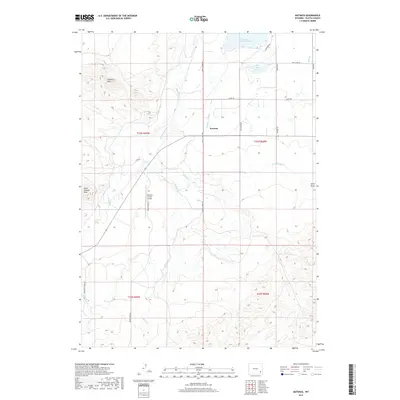
2017 Map of Natwick
USGS Topo · Published 2017About this map
The high plains of Platte County are defined here by a sophisticated network of irrigation infrastructure and water management. Natwick serves as a focal point for the surrounding ranching landscape, where Two Bar Ditch, Canal Number 3, and Number 1 Lateral redirect water across the terrain to support local agriculture. The northern portion of the quadrangle is dominated by significant water bodies, including Reservoir Number One and Rock Lake, which stand in contrast to the arid rises of the Cooney Hills and South Cooney Hills to the west. This map illustrates the intersection of natural drainage and human engineering, as Sybille Cr and Brush Cr flow through a region also served by the Two Bar Ranch Airport. Local transport is facilitated by a grid of named roads such as Sybille Creek Rd and Grange Rd, which connect the scattered homesteads and ranches characteristic of this Wyoming landscape.
Find a feature on this map
30 named features on this map. Tap any name to fly to it.
Don’t see what you’re looking for? This feature index may not catch every label — zoom into the map to look around manually.
Map Details
Editions of this 2017 Natwick Map
This is the sole edition of this map. No revisions or reprints were ever made.
Other maps of this area

1896 · Hartville
USGS Topo · 1:125,000

1901 · Hartville
USGS Topo · 1:125,000
1951 · Wheatland
USGS Topo · 1:24,000

1953 · Natwick SW
USGS Topo · 1:24,000

1953 · Double L Ranch
USGS Topo · 1:24,000

1953 · Hightower
USGS Topo · 1:24,000

1953 · Natwick
USGS Topo · 1:24,000

1953 · Squaw Rock
USGS Topo · 1:24,000

1953 · Ferguson Corner
USGS Topo · 1:24,000

1953 · Hightower SW
USGS Topo · 1:24,000