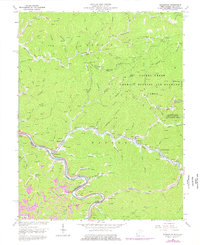
1963 Map of Naugatuck
USGS Topo · Published 1977About this map
Tug River forms the winding border between Kentucky and West Virginia in this mid-century survey, anchoring a landscape defined by the Norfolk and Western rail corridor and deep valley settlements. The community of Naugatuck serves as a central hub where Pigeon Creek meets the river, while smaller mountain hamlets like Blocton, Maher, and Lenore trace the narrow bottomlands. The map reveals an intensive pattern of energy and utility infrastructure, with numerous mines and a pervasive pipeline network traversing ridges like Laurel Ridge. Local family history is preserved through dozens of hilltop burial sites including Marcum Cem, Newsome Cem, and Harden Cem. To the north, the Laurel Creek Public Hunting and Fishing Area occupies a significant portion of the highland, contrasting with the industrial and residential activity clustered along the river's edge.
Find a feature on this map
82 named features on this map. Tap any name to fly to it.
Don’t see what you’re looking for? This feature index may not catch every label — zoom into the map to look around manually.
Map Details
Editions of this 1963 Naugatuck Map
3 editions found
Other maps of this area

1887 · Warfield
USGS Topo · 1:125,000

1891 · Warfield
USGS Topo · 1:125,000

1909 · Matewan
USGS Topo · 1:48,000

1910 · Holden
USGS Topo · 1:48,000

1910 · Naugatuck
USGS Topo · 1:48,000

1912 · Naugatuck
USGS Topo · 1:62,500

1912 · Holden
USGS Topo · 1:62,500

1915 · Williamson
USGS Topo · 1:48,000

1915 · Naugatuck
USGS Topo · 1:48,000

1915 · Matewan
USGS Topo · 1:48,000