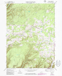
1969 Map of Nauvoo
USGS Topo · Published 1986About this map
Nauvoo lies at the heart of this mountainous transition between Tioga and Lycoming counties, where the high plateaus of the Tioga State Forest drop toward the southern valleys. The landscape is defined by the steep relief of Babb Ridge and Sugar Hill, dissected by a dense network of watercourses including Little Fall Creek and Blockhouse Creek. Evidence of earlier transport and industry is visible in the Old Railroad Grade and the historic Plank Road, which once served the timber and coal interests of the region.
Find a feature on this map
28 named features on this map. Tap any name to fly to it.
Don’t see what you’re looking for? This feature index may not catch every label — zoom into the map to look around manually.
Map Details
Editions of this 1969 Nauvoo Map
3 editions found
Other maps of this area

1921 · Trout Run
USGS Topo · 1:62,500

1923 · Trout Run
USGS Topo · 1:62,500

1925 · Blossburg
USGS Topo · 1:62,500

1927 · Blossburg
USGS Topo · 1:62,500

1937 · Waterville
USGS Topo · 1:48,000

1943 · Waterville
USGS Topo · 1:62,500

1944 · Blossburg
USGS Topo · 1:62,500

1944 · Trout Run
USGS Topo · 1:62,500

1946 · Antrim
USGS Topo · 1:62,500

1946 · Antrim
USGS Topo · 1:24,000